Market Street Railway x Dress-Lace Inc Mini Lace Dress – Gray / Elbow-Length Sleeves
Author: David Dugan

Reunifying the Wharf, Extending the F-line to Fort Mason
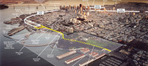
While National Park lands are a major destination of the planned streetcar extension to Fort Mason, connecting western Fisherman’s Wharf to regional transit and the rest of the waterfront is a big benefit as well. Market Street Railway illustration, Robert Campbell photo.
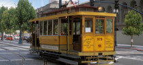
Streetcars Get A New Life in San Diego
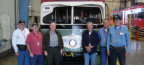
San Diego Vintage Trolley volunteers, including Market Street Railway members Dennis Frazier (second from right) and Dave Slater (right), pose with (left-right) Chuck Bencik, Ron Sutch, Harry Mathis – MTS Board Chair, and Art Aydelotte in front of the repainted nose of car No. 531 (ex-Muni No. 1170). Rick Laubscher photo.
What Have We Learned: Operations
In What Have We Learned? we discussed what we have learned since the first Trolley Festival 25 years ago about the pluses and minuses of various vintage streetcar types in F-line service. Now, we discuss what we’ve learned about operations over that period.
Tales from the Grip: ‘Rookie bites’

(Hmmm … half a column already — not bad.)
The Ballad of an F-line Trip
In 1901, the poet Gelett Burgess penned a poem that celebrated a cable car ride. Specifically, The Ballad of the Hyde Street Grip chronicled the feeling of riding what was then San Francisco’s newest cable car line, the O’Farrell, Jones & Hyde line, which had opened ten years before. The rule of that day was that any new cable car line was ‘inferior’ at the crossings to older lines, meaning that a gripman on the new line had to drop the cable at every crossing of an older line to keep the grip from slicing through the older line’s ‘superior’ cable, which crossed above the new line’s cable. Since the O’Farrell, Jones & Hyde line was the newest line of all, its gripmen had to drop the cable 22 times on every roundtrip, which is why Burgess wrote, “You are apt to earn your wages, on the Hyde Street Grip.”
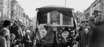
The End of the Innocence: Market Street, 1957
Few felt it, but a seismic shift in American culture had begun. Grandfatherly Ike was President, friendly dairyman George Christopher was Mayor, stalwart Republicans both. Most white, middle-class San Franciscans (the majority then) saw these as comfortable times, and change as not terribly threatening.
Cable Car to Castro
As part of our mission, Market Street Railway creates displays on-board the historic streetcars to educate San Franciscans and visitors on interesting aspects of the city’s transit history. We call it the Museums in Motion project. This is an online version of one of those displays.
See the ‘Dinky’ Streetcar at Castro Street Fair
Market Street Railway will be operating a booth at the Castro Street Fair this Sunday, October 5, from 11:00 am to 5:00 pm, and we’re happy to announce that we will be showing off one of the seldom-seen members of Muni’s historic streetcar fleet: Market Street Railway Co. streetcar No. 578.
Special Delivery
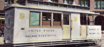
As part of our mission, Market Street Railway creates displays on-board the historic streetcars to educate San Franciscans and visitors on interesting aspects of the city’s transit history. We call it the Museums in Motion project. This is an online version of one of those displays.
Archive: All Posts