John King, the Chronicle’s excellent urban design writer, is taking a look at the “re-imagining” going on about the public space surrounding San Francisco’s most famous transit shrine: the old Ferry Building streetcar loop.
The goal is to create a lively crossroads of enticing fun, rather than the 20 acres of scenic but little-used space that now spills inland from the Ferry Building. Chicago’s lakefront is a model: Millennium Park, where 24.5 acres of train tracks were transformed into a wildly popular phantasmagoria that draws locals and tourists alike. Or Grant Park, where President-elect Barack Obama spoke on election night to more than 200,000 people.
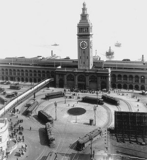
Ferry Loop, around 1927. San Francisco Municipal Railway archives.
Most of the space in question, now called Justin Herman Plaza, was created at the same time as the Embarcadero Freeway went up in the 1950s, by “redeveloping” (in this case bulldozing) a block of older buildings, mostly sailors’ haunts, between Market and Mission Streets, Steuart Street and The Embarcadero, along with other buildings, on the blocks north of Market. As part of the massive redevelopment, the old Produce District gave way to the Golden Gateway residential complex and Embarcadero Center’s office highrises and hotels.
The foot of Market itself was cut back a block, with a aggregate pedestrian way replacing the last block of vehicular use between Steuart and The Embarcadero. And the traditional transit loop (streetcars until 1949, then buses) in front of the Ferry Building, disappeared, with the bus turnaround relocated to an asphalt lot at Mission and Steuart Streets.
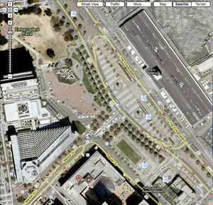
This aerial view, shows the open space around the foot of Market Street is considerable, but very chopped up.
When the Embarcadero Freeway was finally vanquished after the 1989 earthquake, the roadway area itself was remade into a grand boulevard, including the F-line streetcar right-of-way.
The asphalt bus turnaround became the trendy Hotel Vitale, bringing Muni millions in lease revenue and a home for Market Street Railway’s San Francisco Railway Museum.
But the old brick and concrete plaza was little changed (though because it’s technically parkland, the F-line wasn’t allowed to follow streetcars’ traditional path straight down Market to the Ferry Building, but had to loop along Steuart to the south end of the plaza).
Now city planners are rethinking the whole plaza configuration. Streetcars will frame the project visually as well as providing the most visible and attractive transit to and from this new gathering place.
So what do our readers think this new space should look like, and what should it be used for? Let us know in the comments below.

I think that:
1. That hideous fountain needs to go ASAP.
2. Cars should be banned from the embarcadero, and the parking lots seized for more open-space. We need more parks and open-space on the waterfronts. We have a huge number of parking lots on the Embarcadero.
3. More street cafes and restaurants on the Embarcadero area.
4. More F-trains and E-trains.
San Francisco should look to Europe for examples of pedestrian areas that restrict vehicles. It seems as if the embarcadero (or part of it) would be an ideal location for this sort of thing. Of course the MSR fleet will remain.
I believe Justin Herman can be expanded and converted to the hub of activity in SF. JH and the adjacent Embarcadero plazas are grossly under utilised. I would love to see more activity spread north of the narrow walkway that connects Market to the Ferry Building. Also, the sunken plaza and the fountain of JHP feels more of a barrier and should be filled in to grade level. In terms of scale, it is a lot smaller than Grant Park and the expectation should provide more of an initamte green space; however, Drumm Street between Clay and Washington should be removed to connect Embarcadero plaza for a continuous green space. I can envision a nice concert green similar to Millennium Park or Speedway Meadow right by the Ferry Building and waterfront. I would love to see this happen soon.
I’ve got the word “jagged” stuck in my head. Everything at the Ferry Plaza seems to come together at an odd angle, the wrong height, or cuts right through at the wrong spot.
I like all of Phil’s ideas, but what about south of the walkway? I don’t believe I have ever seen a single person on that lawn and it makes your museum look kind of sad, isolated on it’s own away from all the fun up in the sun.
It’s not doing anyone any good now, so how about filling in the lawn and creating a continuous plaza north and south. I picture that actually getting a bit too large, it could look pretty desolate when there’s no tents or booths filling it. It could be broken up with some kind of feature, a statue or fountain midway between the path and the streetcar museum, or maybe an open air restaurant.
I agree with Lava Rat’s phrase: jagged. The space is so odd shaped, it really should be a series of outside rooms, but better framed and used than it is now. I do think, though, that the historic right of way of Market Street between Steuart and The Embarcadero should be preserved. Now, it’s paved in crappy aggregate and festooned with those crafts carts that look like refugees from the last Renaissance Pleasure Faire. It would be great if they would keep it as a hardscape, for pedestrians only as now, but in a more historic finish, like Belgian block or macadam. Not more brick. To the north, there’s enough space for a large concert venue. To the south, that lawn needs to be rethought. Maybe it’s the high water table, but it’s always soggy and not inviting. That whole southern space was designed around the proposal to relocate the 1915 Exposition organ onto the concrete pad at the south end, across from the museum. But that looks dead for lack of funding, so maybe there’s something better there.
I found a rendering of the organ proposal, but it would still leave the problem of the soggy lawn that would still go unused the majority of the time when there’s no concerts going on.
Embarcadero Plaza (that is what the area north of the JHP fountain is called right?) seems much better suited to a concert venue. The hill could be graded to slope down towards the waterfront and is already facing a gap between building where you can see out to the bay.
Remove a part of the plaza and rebuild the trolley loop heck even take the hideous fountain sell it for scrap metal and you have got the money to rebuild the trolley loop bricks and all
I’m with you on the fountain, but that idea to “rebuild the trolley loop bricks and all” is exactly the kind of thing that keeps me from calling myself a railfan.
First off there’s already a loop, the one going around the Hotel Vitale and secondly, if the E-Embarcadero line ever opens then Muni isn’t going to be turning any streetcars around at the Ferry Building during regular service. Though the Chronicle said last week that Muni was going to take down the E-line signs from the N/T stations along the Embarcadero, so it looks like that’s dead now.
Yeah, there’d be something nice about the F going straight through instead of swinging to the south, but it does get the big, noisy, scary streetcars out of the way and the inbound and outbound F-Line stops frame the Ferry Building really well when you look towards it from Market. Look at the historic photos and you see everyone huddled right in front of the Ferry Building waiting for a streetcar, there’s no farmers market or the flea market of booths selling souvenirs to tourists. The loop was there just to get people somewhere else, where today the streetcars going by is one of the things that makes it worth being at.
Have no way of knowing whether it was a railfan who posted the call for a restoration of a loop in front of the Ferry Building, but in any case it’s a non-starter for the reasons you mentioned. The track setup they have now is fine. By the way, those “E-line signs” you referred to were on the ramps for disabled people and were mistakenly installed when the ramps were built. They’ll go back when the E-line finally opens. And the E-line cars are slated to go through to the Wharf, and then be extended to Fort Mason, so there’s no need to create a loop for them.