The F-Market & Wharves historic streetcar line runs six miles each way between Fisherman’s Wharf and the Castro District. Along the way, you’ll see sights both historic and modern.
- The Castro District
- Upper Market & Civic Center
- Union Square & Convention Area
- Financial District
- Ferry Building & The Embarcadero
- Pier 39 & Fisherman’s Wharf
The Castro District
Let’s start in the Castro District. World-renowned as a symbol of gay and lesbian freedom, it is also a neighborhood where people live, work, shop, and dine.
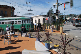 The F-line begins at the Castro District’s popular 17th Street Plaza. Jamison Wieser photo.
There are many great stores and restaurants in the neighborhood, plus the landmark Castro Theater half a block from the F-line terminal, home of the annual San Francisco Silent Film Festival, and ongoing venue for classic movies and pipe organ concerts.
The Castro is an old neighborhood, as you will see from the buildings, originally called Eureka Valley. Initially, rail transit opened it up to settlement, first with waves of immigrant groups made it their home over the years, Germans and Irish mostly. By the 1970s, many gay men and lesbians had settled into the area, revitalizing the housing stock, and opening their own businesses.
One of those businesses was a camera shop run by an ex-New Yorker named Harvey Milk. At a time when most gay people still feared being open about their preference, Milk embraced openness and being ‘out’. His ebullient personality and determined championing of a better urban environment, including better Muni service, won him a seat on San Francisco’s Board of Supervisors (the local equivalent of a city council) in 1977, thus making him one of the first openly-gay elected officials in America.
Tragically, Harvey Milk was assassinated the following year—along with Mayor George Moscone—by former district supervisor Dan White, in one of San Francisco’s bleakest moments. Among many tributes to his memory: an F-line streetcar.
Return to Top
Upper Market & Civic Center
The streetcar dips down to reach Church Street, then climbs up a block to Dolores. Walk three blocks south on that palm-lined street to 16th and Dolores, and you’ll see a Catholic church. Just beyond, tucked away, is the historic Mission Dolores, founded by Father Junipero Serra in 1776. It’s the oldest intact building in the city, with a small museum and lovely garden.
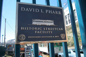 Chris Darringer photo.
At that same Dolores Street/Duboce Avenue stop, you’ll see the Market Street Railway’s Pharr Division restoration facility, located beneath the monolithic ‘new’ U.S. Mint (1937) atop its serpentine bastion. Neither our restoration yard nor the Mint is normally open to visitors.
Coming down the hill, the most impressive landmark is invisible. From the late 1950s until 2003, a freeway whipped across Market at Octavia Street—double-decked most of its life. It cut off views of the Ferry Building and Downtown, and psychologically split off this end of Market. Damaged in the 1989 earthquake, voters decided to take it down (but in true San Francisco fashion, only after a protracted fight).
The mid-Market section stretches for several blocks in this area, featuring a variety of antique shops and other businesses. The F-line then crosses busy Van Ness Avenue (US 101, linking the Golden Gate Bridge to the Bayshore Freeway). Three blocks north of the Van Ness F-line stop is San Francisco City Hall, perhaps America’s most magnificent municipal building, recently restored to its original 1915 appearance. Davies Symphony Hall and the Opera House are across Van Ness Avenue from City Hall.
The next stop, Ninth & Larkin, is just a block from the modern Main Library, and two blocks from the Asian Art Museum, which took over the location of the old Main Library.
Return to Top
Union Square & Convention Area
Fifth Street is the stop for the Powell Street cable car turntable. This is generally thought of as the beginning of the retail district, just blocks from Union Square. The large San Francisco Shopping Centre is on the corner, linked with the historic Emporium Building. The City’s most historic office building, The Flood Building, built in 1904 and rebuilt after the 1906 earthquake and fire, looms over the Powell turntable. Walk south one block on Fifth, and you’ll see the ‘old’ U.S. Mint, built between 1869 and 1874, and given by the federal government to the City in 2003.
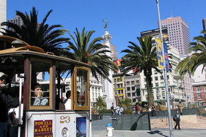 Peter Kaminski photo.
The Fourth & Stockton stop is the shortest walk to Union Square, two blocks north on Stockton Street. One of the city’s oldest public spaces, it was named for rallies held there during the Civil War. This is the heart of the city’s upscale retail area, with a giant Macy’s anchoring the south edge of the square, and stores such as Tiffany and Saks on other edges. Walking the other way from this stop, south on Fourth, brings you to Moscone Center, the city’s convention complex, and Yerba Buena Gardens, a modern oasis built atop the underground convention halls. You can ride the historic 1913 Loop Carousel, from the old Playland-at-the-Beach at Fourth and Howard. You can also reach Moscone Center and Yerba Buena Gardens via the Third & Kearny stop, along with the striking San Francisco Museum of Modern Art one and one-half blocks south.
Return to Top
Financial District
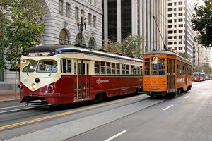 Streetcar no. 1007 passing one of the F-line’s several orange Milan trams on Market Street. Bill Storage photo.
The next stop, Second & Montgomery, brings you to Montgomery Street—the Wall Street of the West—with landmark buildings such as the Russ Building two blocks north.
The F-line then passes through the city’s main high-rise district along lower Market. Landmark buildings on this stretch include the Crown-Zellerbach building at Market & Bush—the city’s first modern skyscraper, built in the late 1950s—and the beautiful ‘twin’ classic office buildings on the south side of Market between Beale and Main: the Matson Navigation building and the Pacific Gas & Electric building.
At the Drumm/Main stop, the California Street cable car terminal beckons at the northern edge of Market and Drumm. The (usually) uncrowded California Street cable line is a great alternative to the Powell Street lines. No curves, but steeper hills, plenty of fun, beautiful scenery, and no waiting in line.
One block farther, the F-line takes a sharp right turn onto Steuart Street, wrapping itself around the historic Southern Pacific Building (now One Market), originally designed after the 1906 earthquake in a U-shape to also serve as a train station (for tracks that were never extended).
Return to Top
Ferry Building & The Embarcadero
The F-line makes a U of its own here, to get around Justin Herman Plaza, a vibrant open public space.
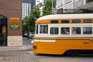 Streetcar no. 1075. David Dugan photo.
The trolleys cut through their own right-of-way, named for the late Don Chee, the Muni leader who managed the F-line construction, to reach The Embarcadero. At the Steuart Street stop, you’ll find the free San Francisco Railway Museum. Step off for a visit and use your fare receipt to resume your streetcar trip, without an extra fare.
As the trolley turns onto The Embarcadero, the landmark 1898 Ferry Building dominates the scene, with its clock tower modeled on Spain’s Seville Cathedral. The clock has only been stopped three times in its history—by the 1906 earthquake, the 1989 earthquake, and a dramatic restoration and renovation, completed in 2003, that has converted the old transportation hub into an epicure’s Valhalla…one of the leading gourmet food marketplaces in the country.
On Saturdays, the permanent vendors are joined by a renowned farmer’s market.
 Streetcar no. 1077. Rick Laubscher photo.
Heading north along The Embarcadero, remember that this was San Francisco’s booming maritime center for decades. The landmark pier bulkheads (the arched buildings on the water side) led to bustling finger piers where squads of longshoremen unloaded cargoes from everywhere. A steam railroad ran the length of The Embarcadero. Taking out the disused railroad track in the 1990s made space for the beautiful waterfront boulevard you see here, as well as the F-line right-of-way.
The first stop past the Ferry Building, Washington Street, is a gateway to the Jackson Square National Historic District, four blocks west. It is the city’s oldest intact commercial district, dating to 1852, and spared by the 1906 earthquake and fire. Today, antique dealers and art galleries dominate the scene. The famed Transamerica Pyramid adjoins this district, but there is no public viewing area atop the landmark structure.
 Streetcar no. 1055. Steve Ferrario photo.
At the Broadway stop, there is wonderful public access to bay views on the public Pier 7.
Farther along, at the Greenwich Street stop, you’ll see Coit Tower to the west, perched atop Telegraph Hill, an Art Deco 1933 monument to San Francisco’s volunteer firefighters of the distant past. Wonderful Depression-era murals with social and historical themes wrap around the inside of the tower’s base.
Great views are available from the top of the tower, and on the way up as well. If you get off at Greenwich and walk west (away from the water), you’ll pass through the park-like Levi’s Plaza, headquarters of Levi Strauss & Company. Walk toward the hill on either Greenwich or Filbert Street (one block south), and you’ll come to a cliff with tenuous staircases clinging to their face. These stairways are actually city streets. The rights-of-way of these streets on the hillside have been turned into beautiful gardens by residents. The Filbert gardens are especially lovely, planted by the late Grace Marchant over decades in the unforgiving, rocky soil of the hill. Old cottages once owned by sea captains flank the gardens and boardwalks constitute side streets.
You can reach Coit Tower by either the Filbert or Greenwich Steps, but be advised it’s a strenuous climb. An easy alternative is staying on the F-line until you reach the Pier 39 stop, then walking across the street to Beach & Stockton to catch Muni’s 39-Coit bus, which reaches the tower via a scenic route through North Beach.
If you’re headed for Alcatraz, the National Park Service boats leave from a dock just south of Pier 33. You’ll want to get off at the Bay Street stop.
Return to Top
Pier 39 & Fisherman’s Wharf
Usually ranked as America’s most visited attraction, what tourists think of as Fisherman’s Wharf begins at Pier 39 (itself a major visitor attraction of shops and entertainment), and extends west to the terminal of the F-line and beyond.
 Streetcar no. 162. Steve Ferrario photo.
The Embarcadero ends in this area, and the F-line merges onto Jefferson Street westbound to reach its terminal at Jones, returning on Beach Street, one block south.
On Jefferson, either the Powell or Taylor stops will deposit you in the middle of the Wharf action—but Taylor is the stop for the heart of the Wharf—Restaurant Row and the fishing fleet.
From the last stop, on Jones Street, walk west two more blocks on Jefferson to reach San Francisco Maritime National Historic Park, a world-class collection of historic ships and maritime memorabilia in a unique national park setting. The Hyde Street cable car terminal and Ghirardelli Square is there too.
Market Street Railway and the Park are among many groups striving to extend historic streetcar service to directly serve the park, and another national park unit beyond at Fort Mason.
End to end, the F-line runs six miles each way…and passes through more than 150 years of history.
Return to Top