There are three different cable car lines that operate in San Francisco, The Powell-Mason, Powell-Hyde, and California Street lines. Here’s a brief description of the routes of each line.
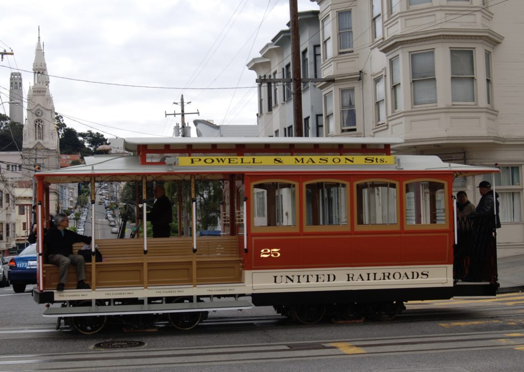
The Powell-Hyde & Powell-Mason Lines
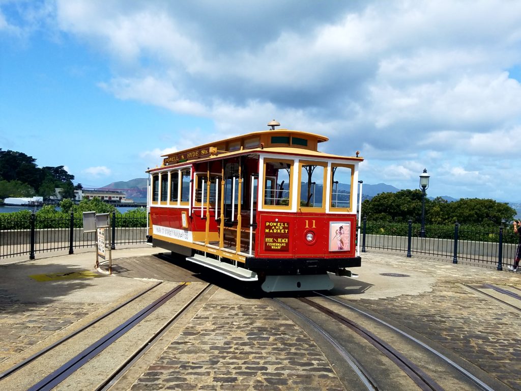
Two of San Francisco’s three cable car lines connect the Union Square area downtown with Fisherman’s Wharf. The Powell-Mason and Powell-Hyde lines share the most-photographed cable car turntable, where Powell meets Market Street.
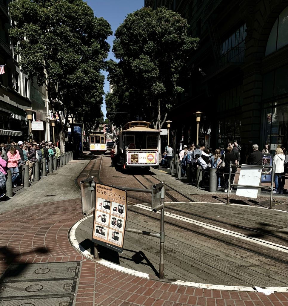
Both Powell Street lines (Powell-Mason cars carry yellow route signs on the roof and destination signs on the ends, Powell-Hyde cars maroon) share the tracks on Powell Street, which has had cable car service with cars just like these since 1888.
Three blocks from the turntable, you’ll pass Union Square, a city landmark since the Civil War, on your right, and the legendary St. Francis Hotel on your left. The City’s most upscale retail shops are in this area. At Sutter Street, you’ll begin a steep three-block climb up Nob Hill. Watch the gripman as you approach California Street at the top. Because the California Street cable crosses above the Powell cable, the Powell cable must be dropped lest it slice the California cable in half, and the cable car must coast across the intersection. The cable car gripman must “drop the rope” precisely as the Powell car crests the hill, or the car will lose its momentum and slide backwards to Pine Street. It’s probably the trickiest maneuver a grip has to execute on the system. A little tower has stood at the corner of Powell and California Streets since 1907, with a signal person inside to ensure Powell and California cable cars don’t crest the hill at the same time.
Once California Street has been crossed, the Powell cars coast downhill, off the cable, for three and a half blocks until the tracks split between Washington and Jackson Streets. There, cars on each line pick up a separate cable to continue their trips to different parts of Fisherman’s Wharf. This is a good place to get off to explore Chinatown by walking downhill to Stockton Street and Grant Avenue.
Powell-Mason Line
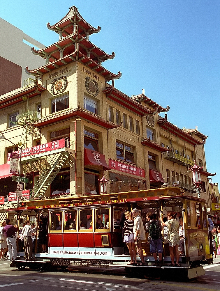
Powell-Mason cars continue one block up Jackson, then lurch right onto Mason Street (the Cable Car Museum is a block to your left, at Mason & Washington), which they follow along the eastern shoulder of Russian Hill into North Beach (get off at Union Street to enter the heart of North Beach at Washington Square). After a short jaunt down Columbus Avenue—the diagonal ‘main drag’ of North Beach—the Powell-Mason cars swing onto Taylor Street to their final destination at the Bay & Taylor turntable.
Since opening in 1888, the Powell-Mason line has run the exact same route with the same type of equipment and propulsion—that’s longer than any other transit line in the world. When the line opened, Bay Street was, well…where the bay began. But subsequent landfill means you have to get off and walk three blocks farther on Taylor to reach Restaurant Row, at the heart of Fisherman’s Wharf, where the fishing fleet is docked along Jefferson Street. (On the way, you’ll cross the rails of the historic F-line streetcars that run back toward downtown along Beach Street to The Embarcadero). This is also the cable car line which brings you nearest to Pier 39.
The Powell-Hyde line
From where the two Powell Street lines split between Washington and Jackson, Powell-Hyde cars parallel the Powell-Mason cars for one block on Jackson Street, on an unusual ‘gauntlet’ track (two slots and two outer rails, with a single shared center rail.) This ingenious solution provides separate cables for the cars of each line uphill on that narrow block. At the end of that block, Hyde cars “drop the rope” again as they cross the track that returns the Mason line to Powell from the Wharf. Hyde cars then retake the cable and climb past the cable car barn and powerhouse (home to the Cable Car Museum) for half a block.
All three cable car lines use this track to ‘pull in’ at the end of the shift. It’s a sight worth watching. The car pulls past the pull-in switch, the gripman drops the cable, yanks on the brakes hard while the conductor jumps off and leans on the switch lever. The brakes come off and the car rockets backwards into the barn—without passengers, of course—where it is flipped around on a turntable and pushed by a small tractor onto a storage track.
Once past the car barn, the Powell-Hyde cars continue across Taylor, Jones, and Leavenworth until they reach Hyde Street.
Until 1956, cable cars on this route continued west on Jackson another eleven blocks into the heart of tony Pacific Heights, terminating at Alta Plaza Park on Steiner Street, then returning via Washington Street. But in the ‘rationalization’ of the cable car system, the old Washington-Jackson line was cut back and connected with the outer end of the old O’Farrell, Jones, and Hyde line, which started operations in 1891. But since the Powell-Hyde line has now been in operation since 1957, it’s historic in its own right.
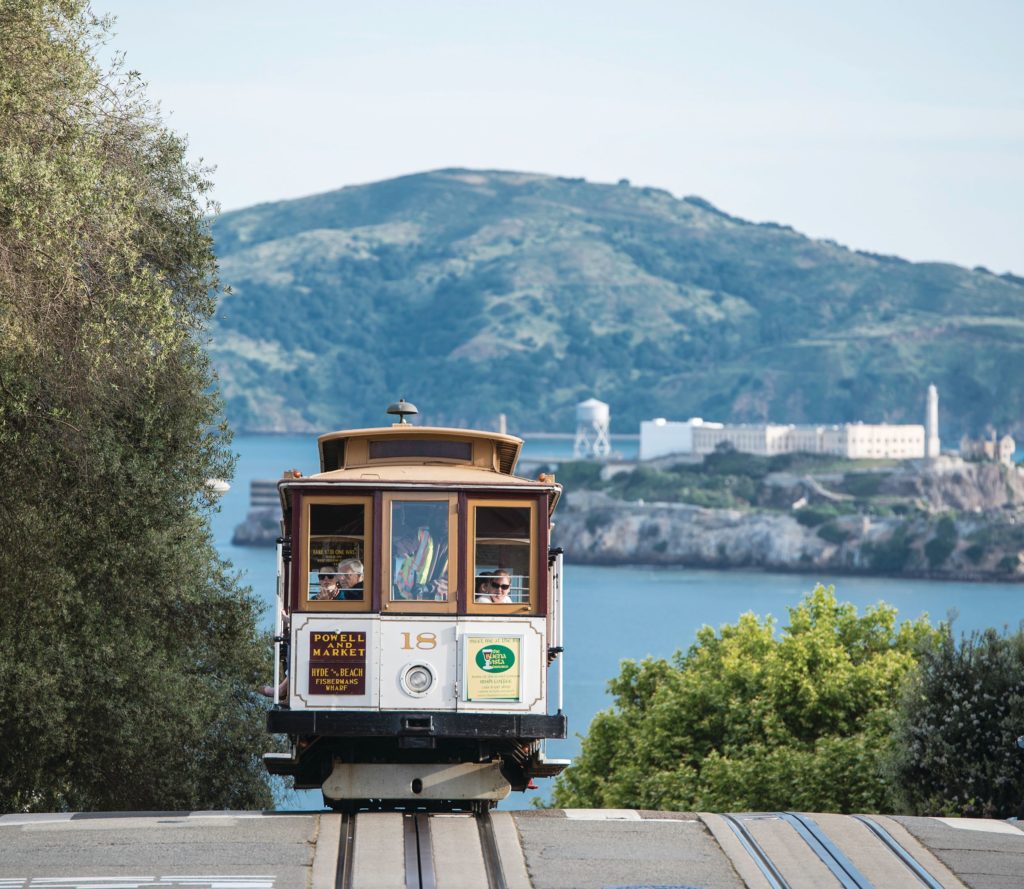
Many riders consider the thirteen-block stretch on Hyde Street to be the most scenic and exciting part of the entire cable car system. The Powell-Hyde cars run through an allee of ficus streets in the colorful neighborhood of Russian Hill, passing restaurants, shops, venerable apartment buildings, and homes along the way. At Lombard Street, Wharf-bound cars pause while riders gawk at the ‘Crookedest Street in the World’. The cars aren’t making a photo stop, however: roadside signals tell the crew when it’s safe to descend the steepest grade in the cable car system—a harrowing 21 percent slope—a loooonng two blocks from Chestnut to Bay Street, while riders drink in a soaring vista of Alcatraz, Angel Island, Mount Tamalpais, and the Golden Gate Bridge.
From Bay Street, it’s two more blocks to the end of the line at Beach, the western edge of Fisherman’s Wharf. One block straight ahead is the Hyde Street Pier, where automobile ferries operated to Marin County before the Golden Gate Bridge opened in 1937 (one of those ferries is preserved there along with other historic vessels as part of San Francisco Maritime National Historic Park). One block west is the famous Ghirardelli Square.
The return trip on Hyde departs from the turntable tucked inside Victorian Park, now part of the larger Aquatic Park. Many assume the turntable is very old, but actually, the old O’Farrell, Jones & Hyde line used double-end cars and a switchback, so there was no turntable at all until 1957, when one was constructed for the single-end Powell type cars in what was then a neglected vacant lot. The park around the turntable came later. The entire turntable area was reconstructed and somewhat altered when the cable car system was rebuilt in 1982-84.
California Street line
The California Street cable car line provides a genteel counterpoint to the bustling Powell Street lines.
On any given trip, you’ll find far more San Franciscans on board than you see on Powell cars—often a majority of riders are locals, commuting to and from work. That’s because Cal Cable comes nowhere near the tourist magnet of Fisherman’s Wharf.
Most visiting riders start at the east end of the line, two blocks from the Ferry Building at the three-way intersection of California, Drumm, & Market Streets. It’s easy to reach from the F-line historic streetcars (Main/Drumm stop), from the BART/Muni Metro Embarcadero station, or from our San Francisco Railway Museum.
For the first five blocks, Cal cars take you through the deep canyon of lower California Street, where the cable car looks out of place against the high-rises of the Financial District. Even here, though, there are pieces of the past, such as the Tadich Grill on California near Battery—the oldest restaurant in California, and still a hopping experience. The street is flat until the Cal cars reach Montgomery in the shadow of the 52-story Bank of America building. Up to this point, the ride is relatively tame (some might say boring), but beginning at Kearny Street, things get interesting.
Two blocks north on Kearny is Portsmouth Square, where the American flag was first raised over California in 1846 (when San Francisco was still called Yerba Buena). It’s now the green heart of Chinatown, one of the best places in the city for people watching. One more steep block up California and the Cal cars reach Grant Avenue, the main street through Chinatown. Walk in either direction from this stop and you’re immediately in the middle of it all. Old St. Mary’s Church is a long-time landmark on the corner.
Two more steep blocks, and the Cal cars arrive at Powell Street, where all three cable car lines intersect. With the exception of early morning and late evening, it’s tough to get a space on a Powell car going to the Wharf from here, so keep riding.
Now the Cal cars crest the top of Nob Hill. (The California Street cable car line was originally built in 1878 by Leland Stanford, partner in the Central Pacific Railroad—part of the first transcontinental line—which opened up California to the rest of the world. Stanford and his partners, Mark Hopkins, C.P. Huntington, and Charles Crocker, all had fantastic mansions on Nob Hill. Stanford and Hopkins lived side by side on California between Powell and Mason, where hotels carry on their names today.) The ‘Top of the Mark’ cocktail lounge, famous since it opened around 1940, provides great views and a real San Francisco ambiance. The Mason Street stop serves both the Mark Hopkins and grand Fairmont Hotel across California Street, another landmark recently restored to its original grandeur.
As the Cal cars crest the grade at Mason, you’ll see the gripman drop the cable at the last minute. This is not because a cable car line with a higher cable crosses here (as happens for the Powell cars crossing California), but because the cable takes a 90-degree right turn here and runs without track for three blocks north under Mason Street to reach the cable car barn and powerhouse. This arrangement was installed when the cable car system was consolidated in 1957. As the Cal cars continue west, note the Flood Mansion on the right, last of the original palaces to survive (almost all were destroyed in the 1906 earthquake and fire). It is now the very exclusive Pacific Union Club.
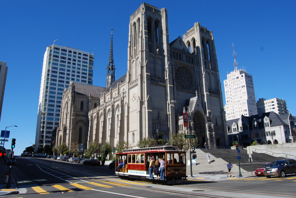
Next to it is Huntington Park, named for C.P. Huntington, and across from the park in the Huntington Hotel, an elegant restaurant named ‘The Big Four,’ themed around old California, particularly the railroad days. At Taylor Street is the imposing Grace Cathedral, a landmark Episcopal Church comparable to some of the great cathedrals of Europe.
For the remainder of the route, the Cal cars pass apartment buildings which grow more modest as you get farther down Nob Hill. At the corner of Hyde & California, looking somewhat out of place, is a supermarket. This parcel was the California Cable Railroad Company’s car barn and general offices, serving the cars of both the California and O’Farrell, Jones & Hyde lines until the company went broke in the early 1950s. After Muni took over, they consolidated operations at the Washington & Mason powerhouse, and reworked the track on Hyde Street to let the Cal cars reach their new barn.
It’s interesting to contemplate that if a different consolidation plan had prevailed—one which was proposed by leading members of the Board of Supervisors—the Cal cars would be turning here to run out Hyde Street to Aquatic Park (instead of connecting a Powell line to the Hyde track as ultimately happened). A California-Hyde line, connecting Chinatown’s main street directly to Fisherman’s Wharf via scenic Nob and Russian Hills, would have been much busier and more tourist oriented than a California Street-only alignment, and development patterns would have been different, too.
As it turned out, the Cal cars pass right through Hyde and roll only three more blocks before terminating. Polk Street offers some interesting shopping opportunities with a local neighborhood focus. At busy Van Ness Avenue—which is Highway 101, the main automobile link between the Golden Gate Bridge and downtown—the line abruptly ends. It once extended nearly twice this far, through Pacific Heights to Presidio Avenue (with steam train connections to the beach in the early years), but was cut in half in the 1950s consolidation. There is still a smattering of talk about re-extending the line to a more attractive terminal, either via California and Webster to Japantown, or via Polk to City Hall, but these ideas have never gotten past the talking stage.
Still, if you’re looking for a pleasant cable car ride without the long lines, the California line is the place to go.