San Francisco has been a magnet for travelers for 170 years. The beauty of its setting on one of the world’s great natural harbors is unquestioned. Yet San Francisco’s front door once was ugly.
The Gold Rush of 1849 and the Comstock Lode of 1859 had vaulted the village of Yerba Buena into America’s 15th largest city in the 1860 census. Between 1860 and 1870, the city’s population almost tripled, to 150,000, climbing the ladder to tenth-largest city in America.
The city’s deep-water port and proximity to the precious metal strikes made it far and away the most important city in the West, but its location at the tip of a 45-mile long peninsula made access difficult. In 1869, the Transcontinental Railroad connected California to the East, but it terminated across San Francisco Bay at the Oakland Long Wharf, requiring train riders—and anyone else coming to town from the East Bay—to take boats to reach the city. And when they got here, they were dumped at the dowdy Davis Street Wharf, between Broadway and Vallejo Street, not close to the financial and commercial centers of town.
The first ‘Ferry House’
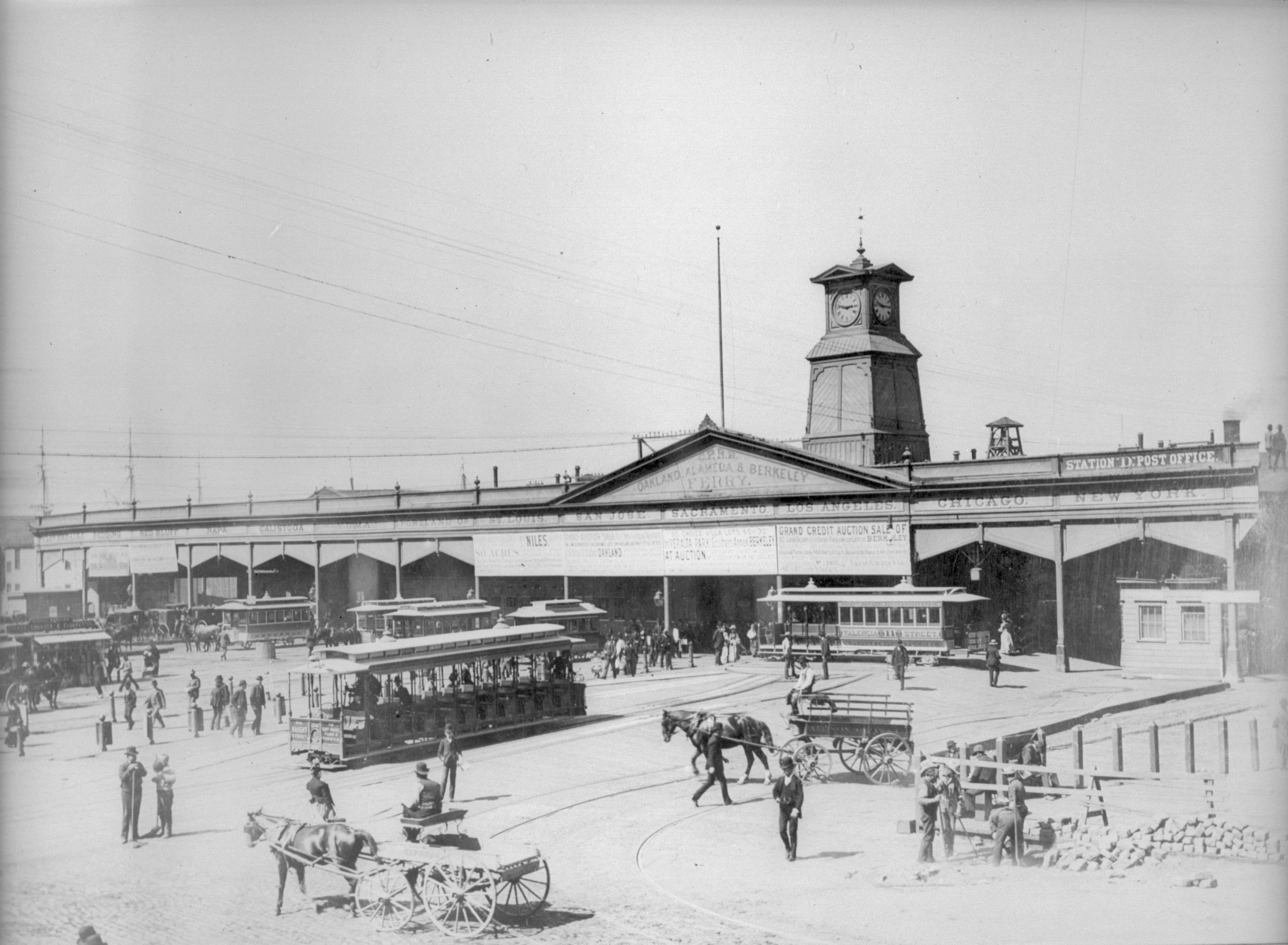
As the volume of Bay commuters burgeoned, there wasn’t nearly enough capacity at the Davis Street Wharf to accommodate them, so in 1875, the Board of State Harbor Commissioners (BSHC) removed the Clay and Commercial Street Wharves just north of Market Street and built a ‘Ferry House,’ a wooden shed ultimately 600 feet long with seven boat slips.
As described in the book Port City by author Michael L. Corbett, “In contrast to the plain industrial sheds elsewhere on the waterfront, the Ferry House displayed a restrained use of chamfered, turned, and jigsawn elements and the planned placements of painted signs in the frieze of each bay.” Corbett says the “orderly arcade across the front…screened a chaotic interior.”
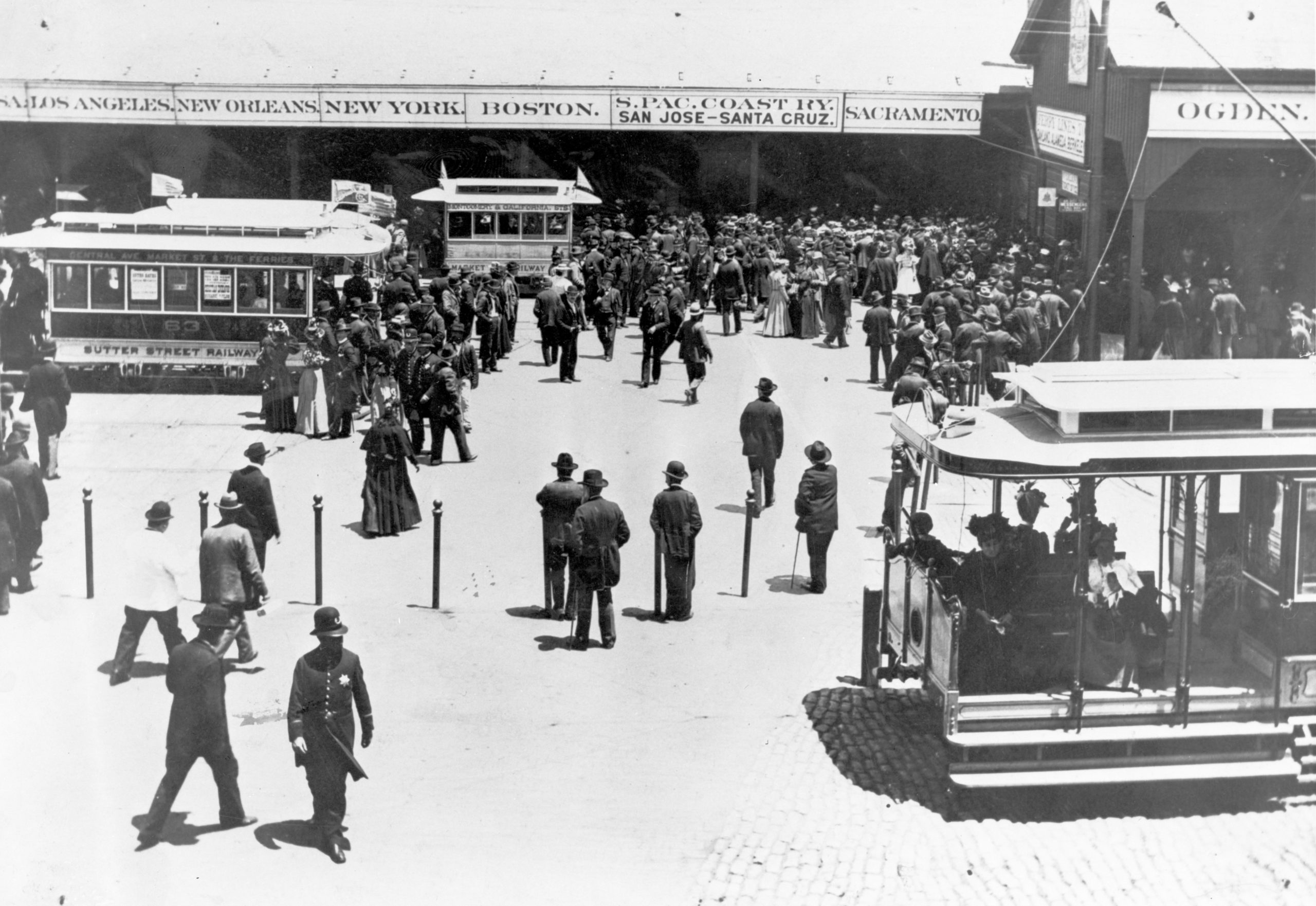
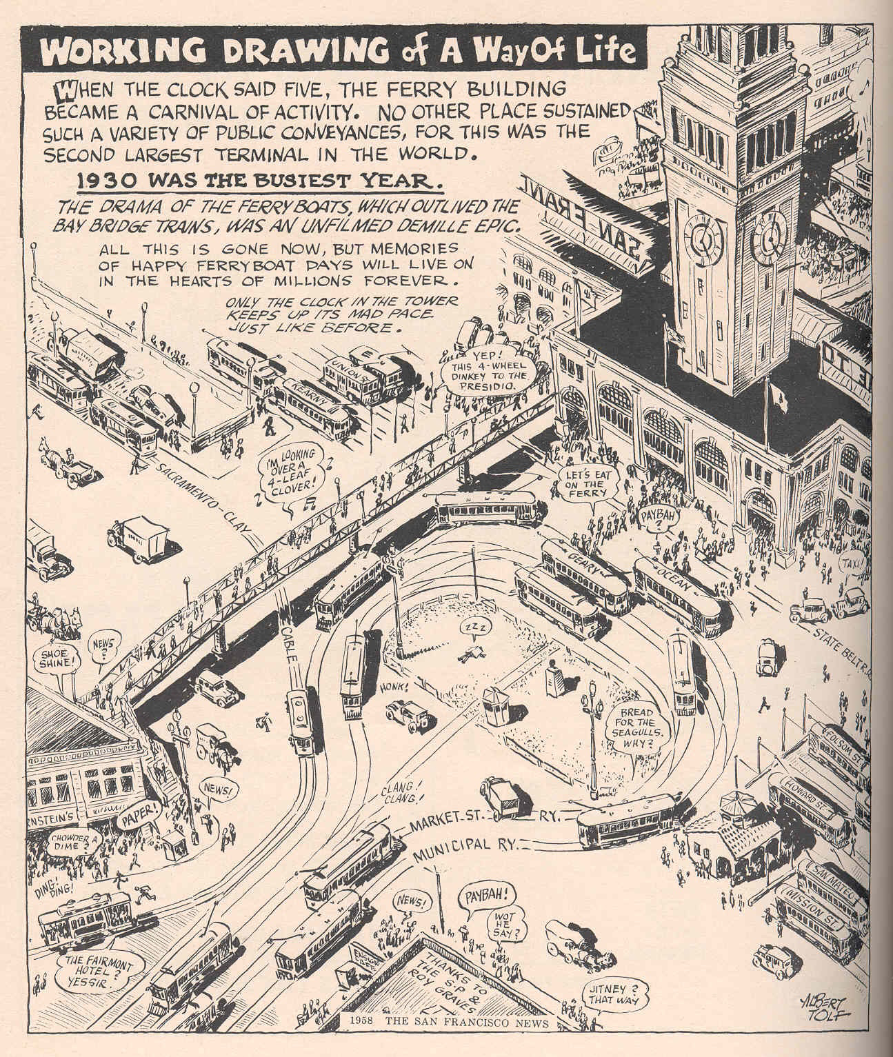
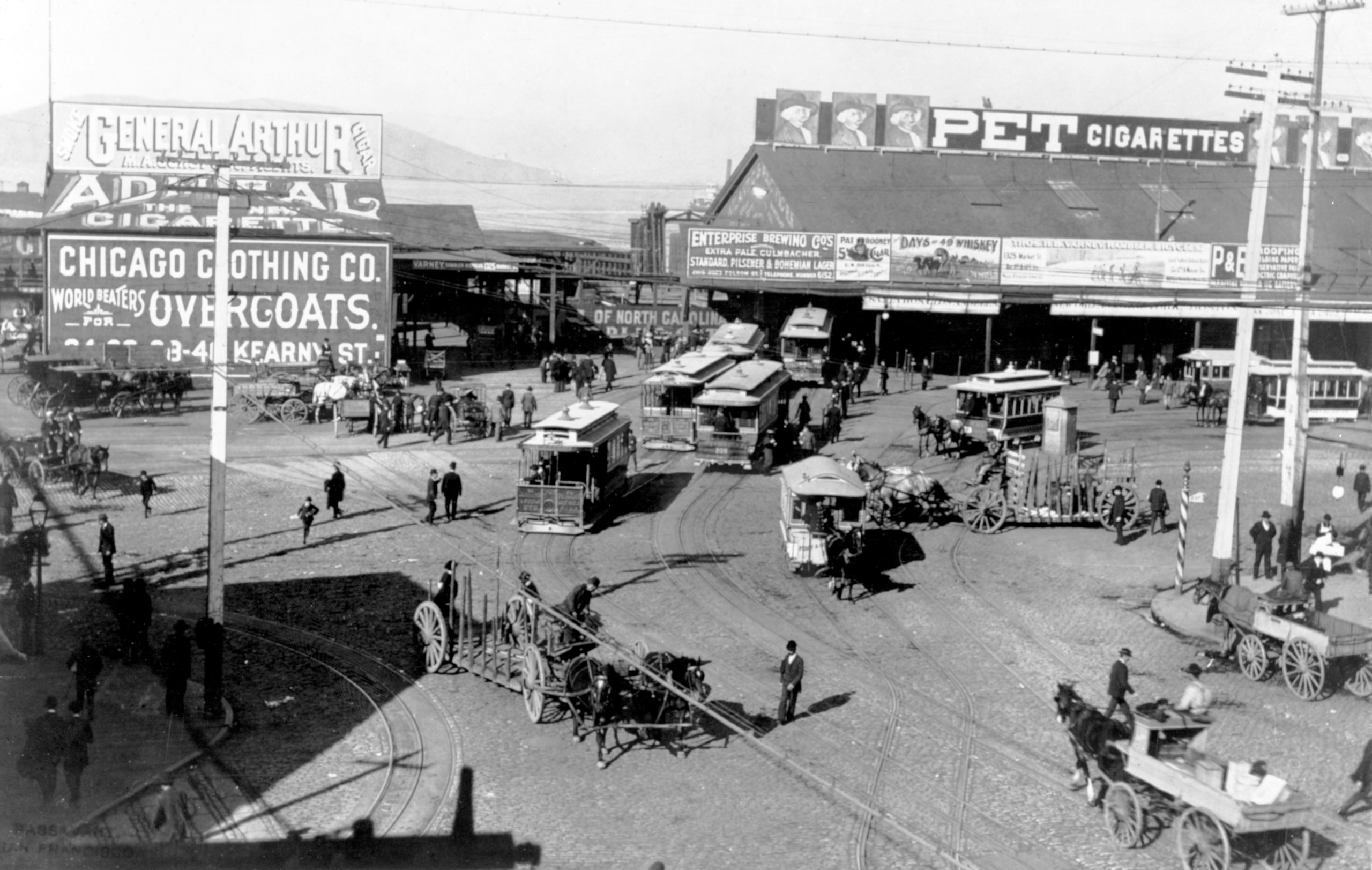
Chaotic indeed, with many vendors competing for passengers’ attention as they rushed between the ferries and the horsecars and Concord stages on the landside at the foot of Market Street. The overall scene grew even more chaotic beginning in 1883 when massive cable cars began running on Market, multiplying transit capacity over the small, slow horsecars. By 1888, there were five cable car lines, reversing on a giant two-track turntable as frequently as every fifteen seconds and heading out to branches on McAllister, Hayes, Haight, Valencia, and Castro Streets.
The great western railroad historian Lucius Beebe chronicled the transit scene in front of the Ferry House thusly: “Horsecars, cable cars, and steam trains operated over an amazement of geographic locales crossing, meeting, receding, shuttling, connecting and converging upon one another like dancers in a pattern of bemuse complexity. They wove back and forth across each other’s lines in a warp and woof of a gigantic fabric…The clangor of their coming and going…rattling over cobbles, Belgian blocks, asphalt, macadam, and steel switches and crossovers comprised a contrapuntal symphony of cosmopolis.” (Must have been loud.)
A grander welcome
It was already clear that the Ferry House was not going to be an enduring terminal, given the residential growth of cities on the East Bay shoreline and the increase in office space in downtown San Francisco. In the late 1880s, the BSHC decided to replace the Ferry House with a larger and more orderly structure. As if to demonstrate how dominant San Francisco was in California commerce and politics back then, the $600,000 bond issue for the new structure had to be approved by voters statewide, and won by only 866 votes out of 181,000 cast in 1892.
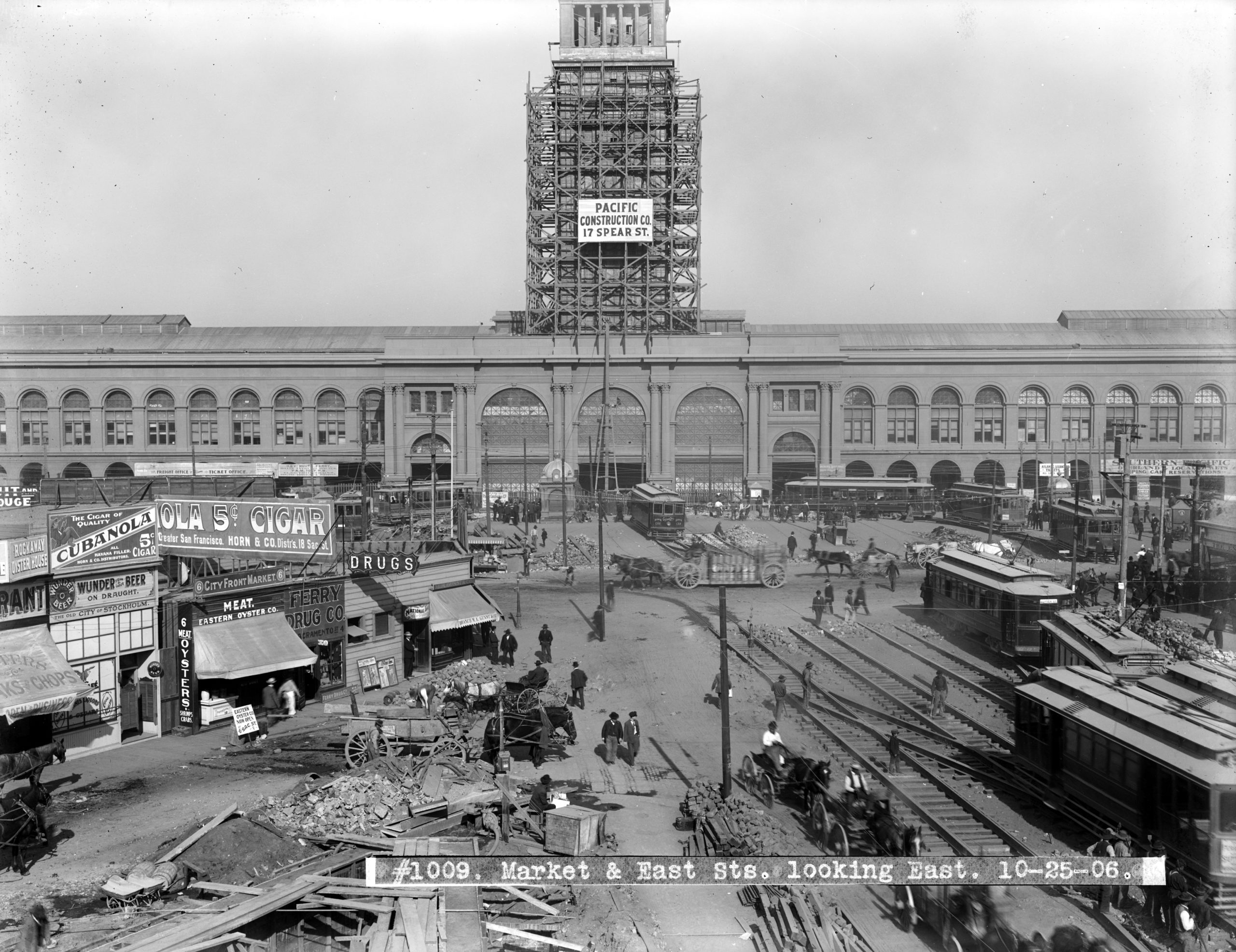
The BSHC then hired architect A. Page Brown, who proposed a 660-foot long main block inspired by the railroad station for the 1893 Chicago World’s Fair, topped by a 240-foot tower modeled on the Giralda bell tower of Spain’s Seville Cathedral. The tower dominates the foot of Market Street, and was intended by the BSHC to be a beacon to ferry riders crossing the bay. It doesn’t face Market squarely, but at a slight angle to accommodate the alignment of the seawall which served as its foundation.
When it opened in 1898, “The Union Depot and Ferry House” (its official name), was an anomaly on the waterfront: the only monumental, substantial building at the water’s edge at that time. The BSHC’s biennial report laid it on thick about its importance: “Through its magnificent corridors, arcades, and waiting rooms will pass the tourist from abroad, with whom first impressions are the most lasting, and from the splendor surrounding the entrance leading him within the portals of the ‘City by the Golden Gate,’ will he judge the enterprise and progessiveness of our people, and will, therefore, inspire him to investigate the resources of our great commonwealth.”
The Ferry Building was an instant anchor to the waterfront, with a huge post office built to its south soon afterward, and businesses of all kinds crowding the surrounding blocks. The city’s population was burgeoning, having more than doubled between 1870 and 1900, to almost 300,000.
The Ferry Building was rocked by the April 18, 1906 Earthquake, but spared from the fire, which incinerated the surrounding blocks. The clock stopped at 5:12 a.m. for months, while workers repaired the damaged tower façade. In the interim, electric streetcars replaced the cable cars and soon, traffic through the Ferry Building was heavier than ever, in part because many San Franciscans, exiled by the quake and fire to the East Bay, chose to stay there and commute to the city on the ferries.
The traffic growth continued when the Municipal Railway began adding streetcars to those of competitor United Railroads in 1913, killing off the last horsecar line and increasing congestion so much that a third loop track had to be built at the Ferry Building in 1918. (URR even designed, but did not offer to pay for, an elevated loop, taking people directly to the second level of the Ferry Building, from which they could walk directly onto their ferry.)
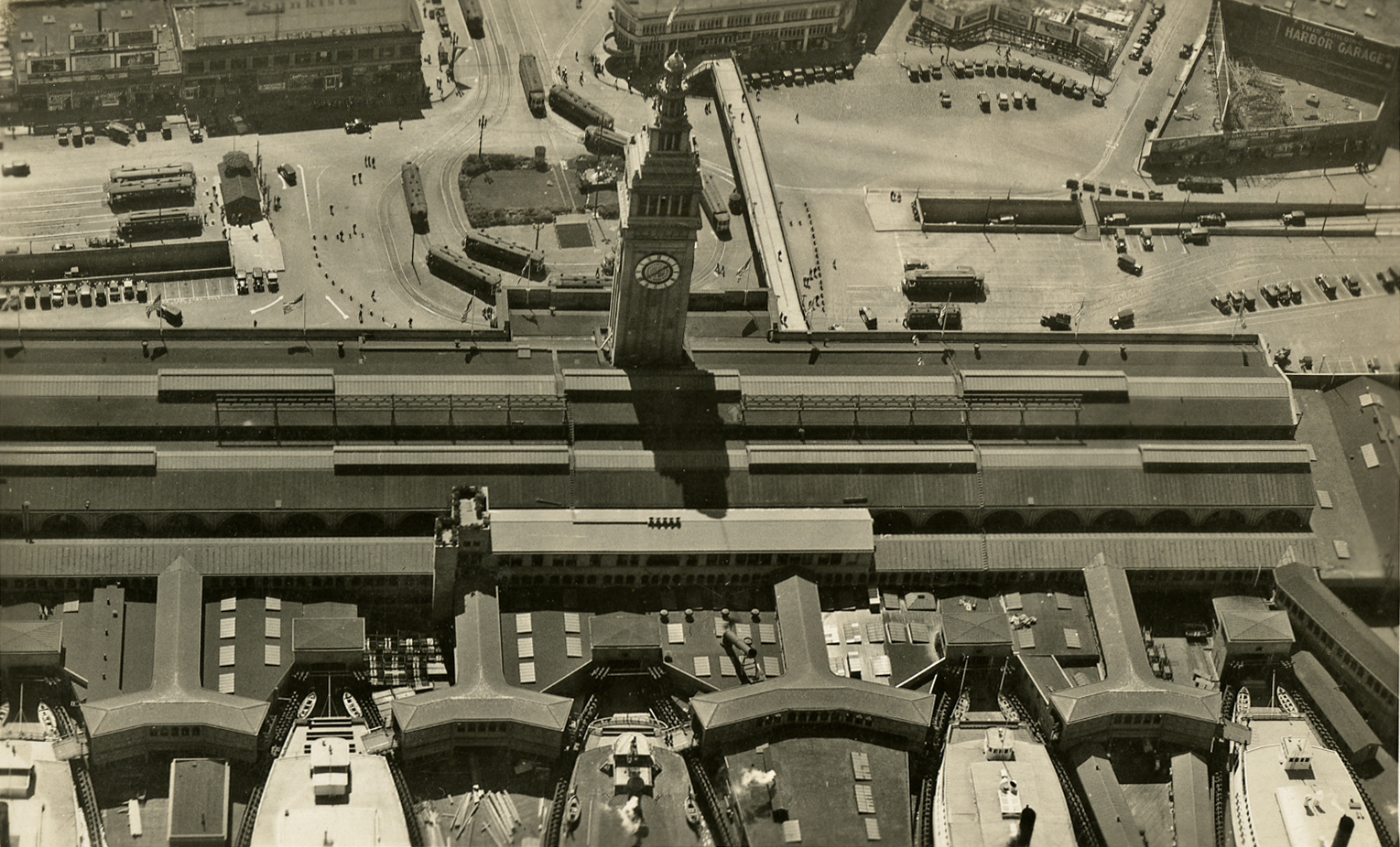
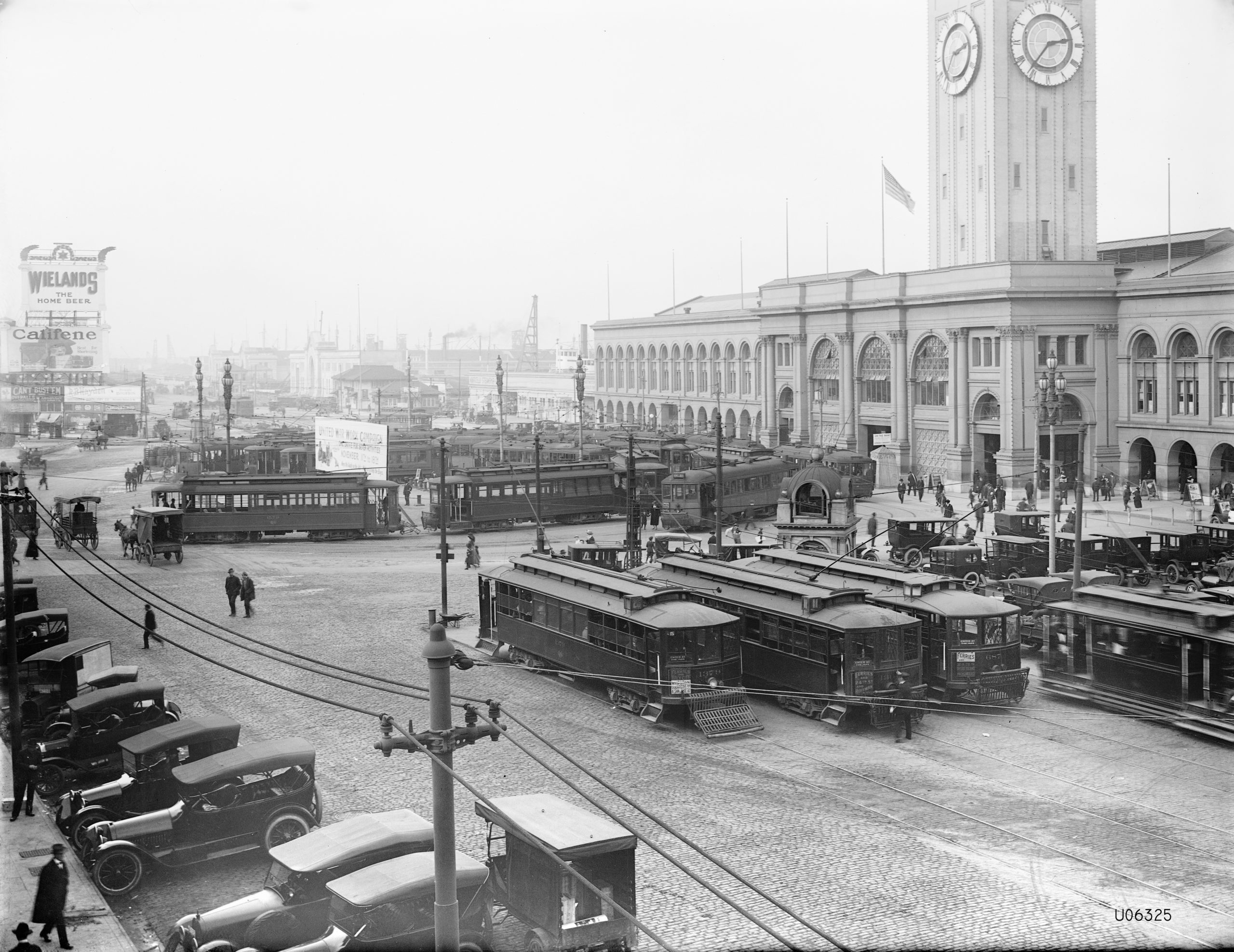
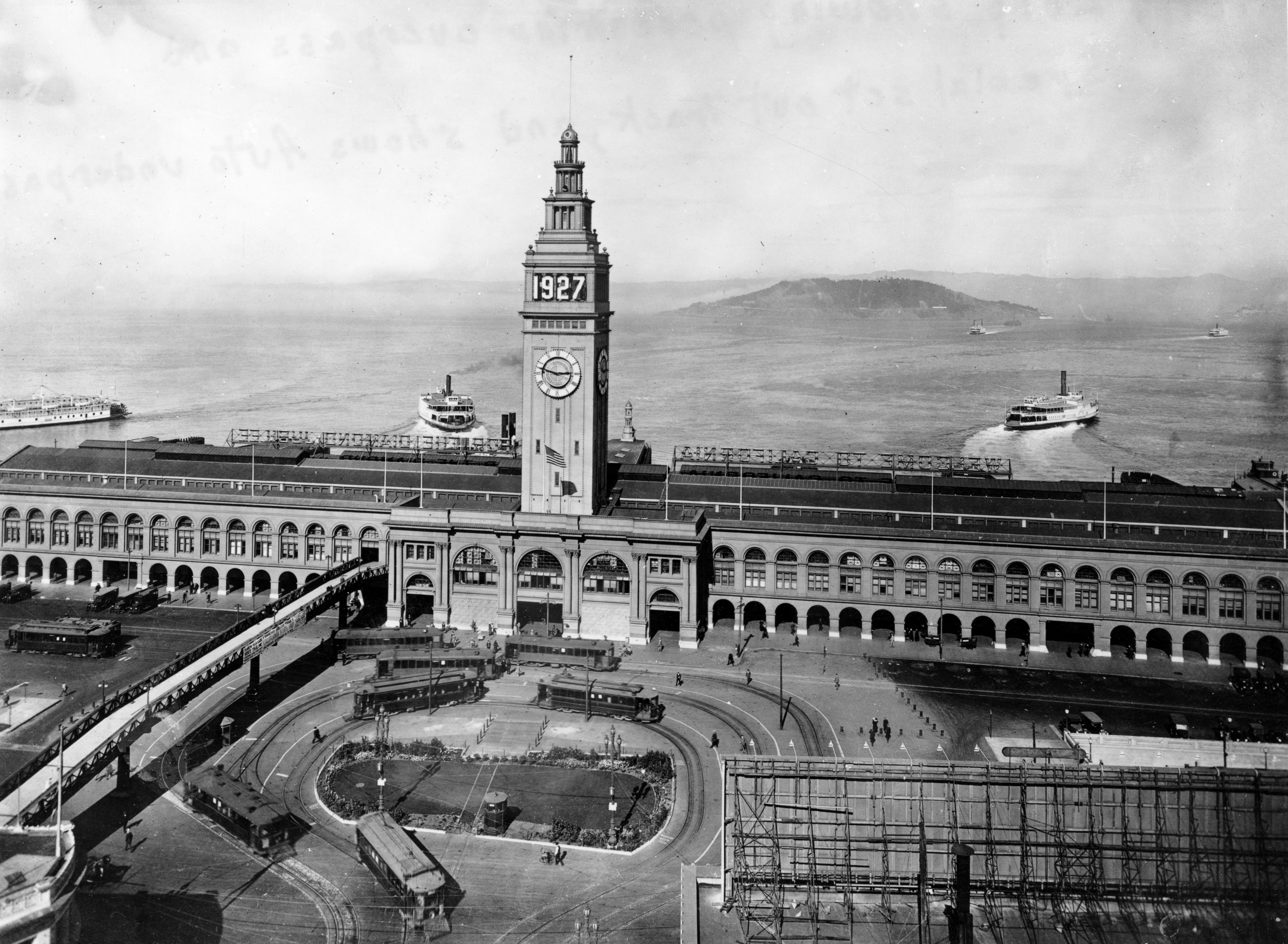
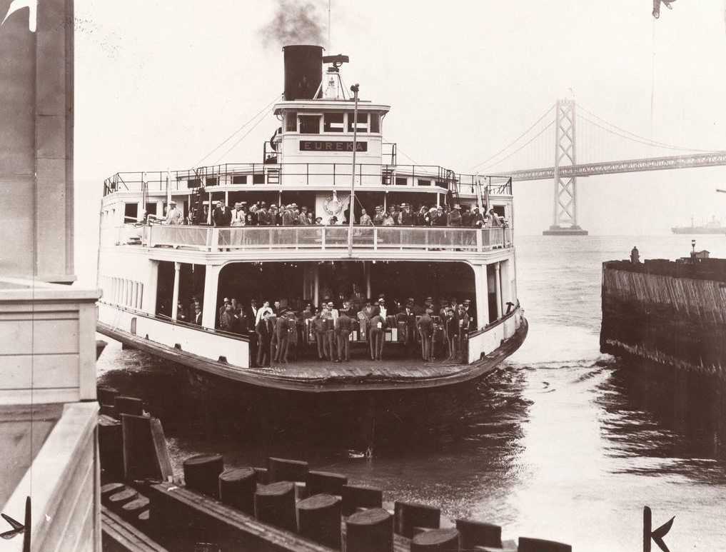
The 1920s and early 1930s were the golden era of ferries on San Francisco Bay. In 1930, 43 ferryboats operated on the bay, the largest number ever. Many were enormous, capable of carrying more than 2,000 passengers seated and another 1,000 standing (the equivalent of three jammed BART trains). The Ferry Building itself was the world’s second busiest transit terminal, behind only Charing Cross in London, with more than 250,000 people a day passing through between the 340 ferry arrivals and departures per day and the streetcars that left the terminal as frequently as every 20 seconds.
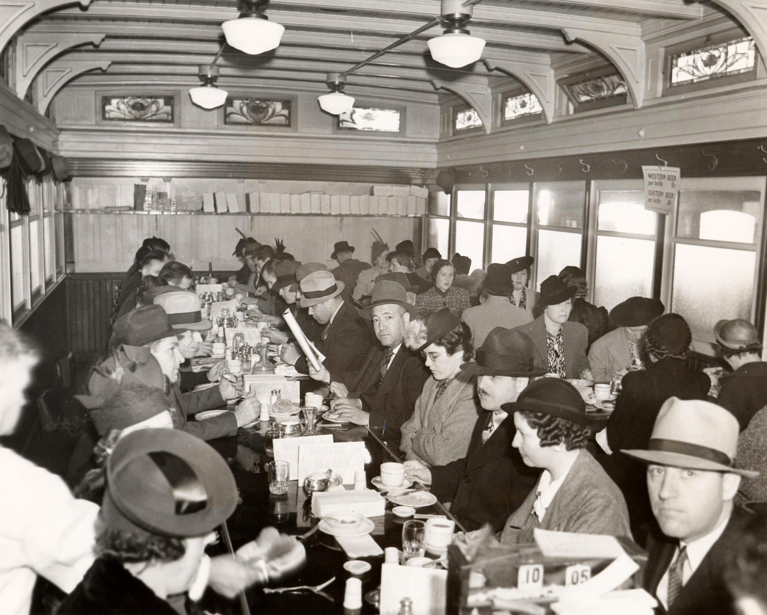
Regular ferry commuters settled into routines, much like their successors on the smaller bay ferries today. Noted transit historian and journalist Harre Demoro recalled that on the 18-minute run from the Oakland pier to the Ferry Building, Key System ferries were equipped with 12-slice automatic electric toasters to get riders breakfast in a hurry. On longer runs, there was time to linger. The Santa Fe Railroad’s passenger ferry service from Point Richmond offered 40 minutes of dining time with white tablecloths and service by the famed Fred Harvey organization. On all the boats, passengers claimed their regular seats and chatted with the same fellow passengers, played cards, or (except during Prohibition) knocked back a few.
On both ends of most Ferry runs, they were met by rail transit. At the 1930 peak, 30 streetcar lines (nine Muni and 21 Market Street Railway) terminated at the Ferry Building (along with the Sacramento-Clay cable car), radiating to all corners of the city. You could reach Ocean Beach at seven different locations via (from north to south) the 2, B, 5, 7, N, L, or 12 lines. You could ride all the way to the Presidio on the D or E, to Daly City via two different routes on the 14 and 26, or to Visitacion Valley and the county line on the 16.
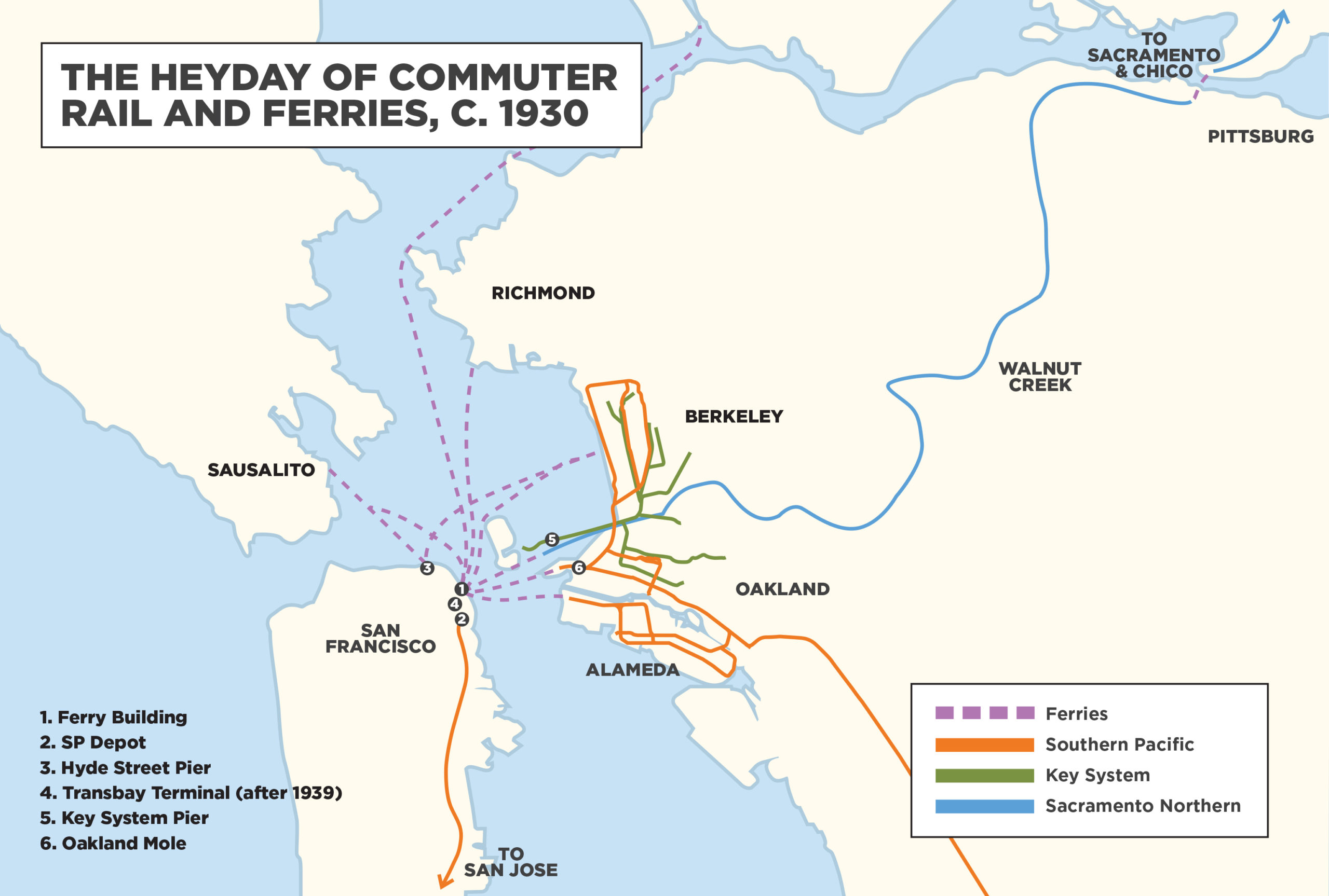
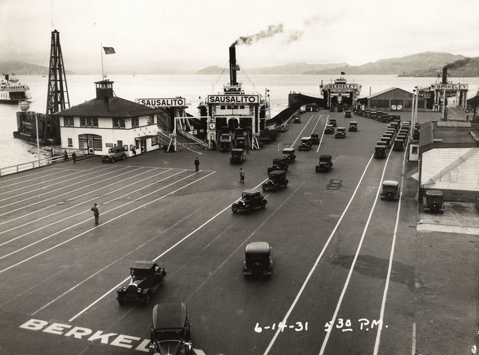
At ferry terminals across the Bay, there were many electric rail options as well. Most ferry traffic into San Francisco came from the East Bay, and the biggest contributor to that was the Key System (named because its routes radiated in roughly the shape of a key from a pier that extended from the Oakland shore almost all the way to Yerba Buena Island). Key System trains served Oakland, Berkeley and Piedmont. Rival East Bay Electric Lines (later Interurban Electric Railway), owned by Southern Pacific, served those cities plus Albany, Emeryville, Alameda, and San Leandro. Those SP-owned electric trains, along with SP’s steam passenger trains for points north, south, and east, connected to SP ferries at its own Oakland Pier (called the Oakland Mole).
There was also the Sacramento Northern Railway, controlled by the Western Pacific Railroad. It ran electric interurban trains from the Key System Pier in Oakland over the East Bay hills to Lafayette, Concord and Pittsburg, then crossing Suisun Bay by ferry to Sacramento and points north, offering direct service as far as Chico, 183 miles from Oakland, making it one of the longest interurban electric train services in the U.S. The Santa Fe Railroad ran ferries that connected the Ferry Building to its long-haul trains at Point Richmond.
So, the Ferry Building served both long-distance travelers on the trains or interurbans, who were coming to experience the stores and attractions of what most considered the leading city west of the Mississippi, and daily commuters, heading across the Bay to work. It was unquestionably the West Coast echo of New York’s Grand Central Terminal.
Yet the “Union Terminal and Ferry House” wasn’t the only ferry landing in San Francisco. The Hyde Street Pier (now the centerpiece of the San Francisco Maritime National Historical Park) bustled with automobiles and passengers (some of whom transferred from the O’Farrell, Jones & Hyde cable car line) in this era. Ferries run by Southern Pacific or its subsidiary Northwestern Pacific took people across the Golden Gate to Berkeley or Sausalito. In Sausalito, they were met by NWP electric trains that carried them north through the county to Mill Valley, San Rafael, San Anselmo, and Fairfax, among other destinations, plus an overnight steam train reaching as far as Eureka, 250 miles north. Marin was sparsely populated then, but many San Franciscans made the crossing to go to weekend homes or to breathe the fresh air.
Other North Bay destinations that could be reached by a ferry-electric train combination included: Napa and Calistoga, via a ‘fast’ (two-hour) boat from the Ferry Building to Vallejo, transferring to interurban trains of the San Francisco & Napa Valley Railroad, and Santa Rosa via an overnight (six-hour) boat to Petaluma and a ride on the Petaluma & Santa Rosa Railroad, primarily a freight operation. Neither operation was heavily used by those headed to and from San Francisco; both ended passenger service in the 1930s.
Trains to the south
The rebuilding of San Francisco after the 1906 earthquake and fire brought the grand Ferry Building a new neighbor: the imposing headquarters of the Southern Pacific Railroad at Market and Steuart Streets, a U-shaped building that was supposedly intended also to serve as the railroad’s San Francisco terminal.
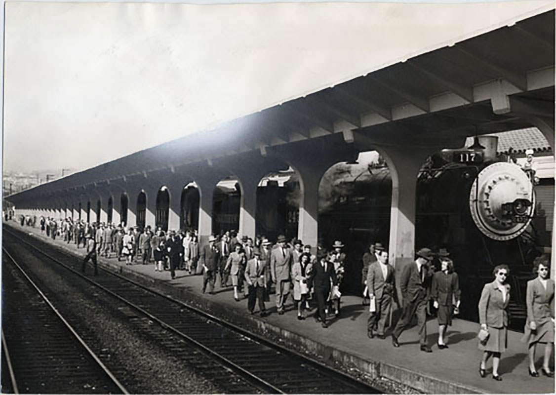
The powerful Southern Pacific, villainized by novelist Frank Norris as “The Octopus,” did indeed control much of the state’s economy (and many of its politicians) in the last third of the 19th century. Its steel tentacles reached everywhere in the state, but it lacked a decent terminal in San Francisco, using a modest structure at Fourth and Brannan Streets. But even the mighty SP couldn’t win approval to close the number of streets in the South Beach area necessary to carry its long passenger trains to Market Street, so it settled for a handsome depot at Third and Townsend in 1914, opening to coincide with the Panama-Pacific International Exposition.
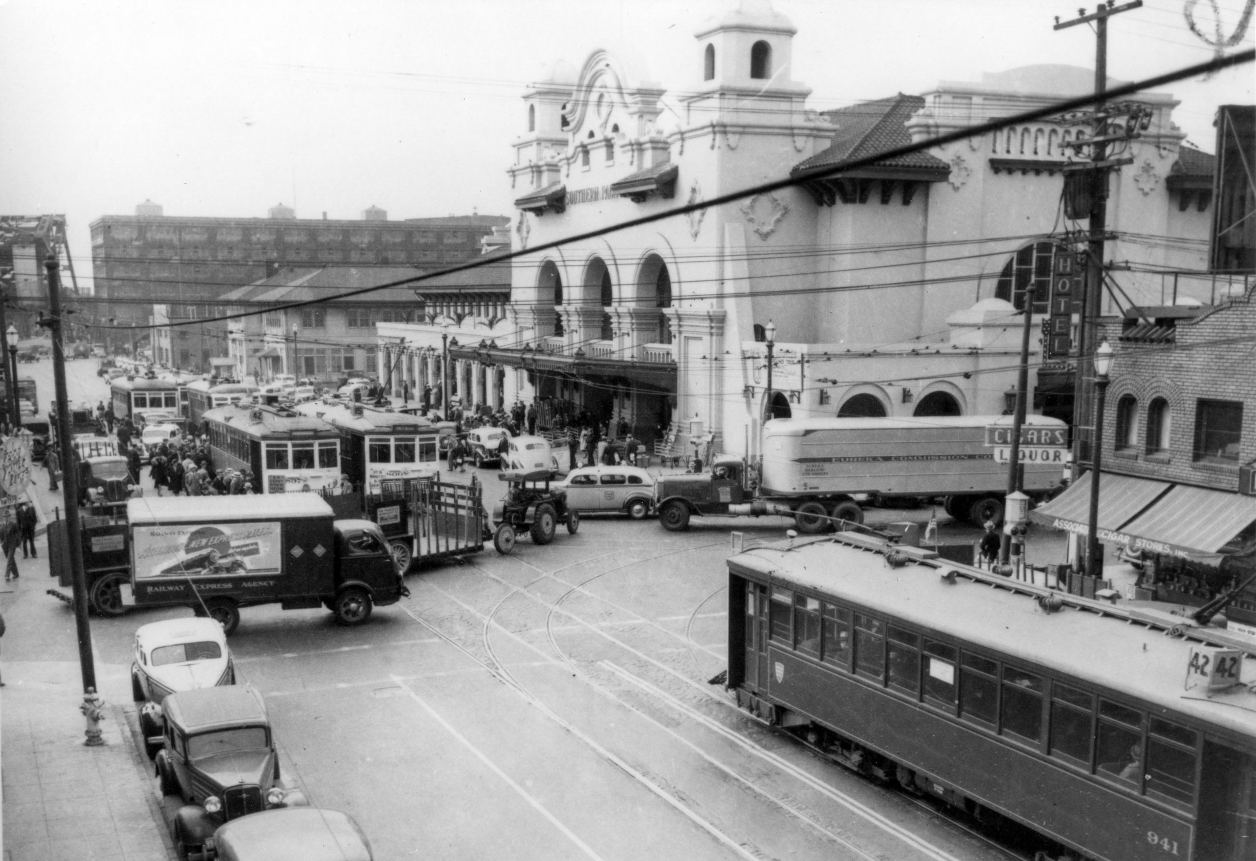
This depot hosted both long-distance passenger trains, including famous names like the Coast Daylight, the Coast Starlight, and the Lark to Los Angeles, along with such famed trains as the Suntan Special to Santa Cruz, the Del Monte to Monterey, and the Sunset Limited to New Orleans. But the bulk of people using the SP Depot were Peninsula commuters using the steam trains that ran as far as San Jose, 50 miles south.
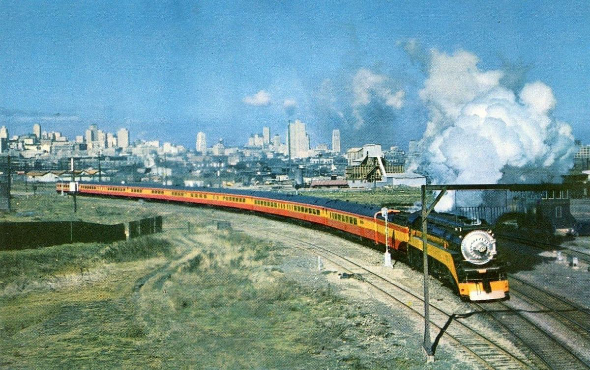
This line along the Peninsula had opened in 1853 as the San Francisco and San Jose Railroad, and was acquired by SP within five years. The track originally looped around the western end of San Bruno Mountain through South San Francisco, Colma, and Daly City, lengthening the commute considerably. In 1907, SP filled the Bay on the eastern edge of the mountain and created the ‘Bayshore Cutoff,’ which brought the trains on a straight line to the terminal. (Decades later, parts of the old SP right-of-way became part of the J-Church line on San Jose Avenue, and BART’s airport extension.)
United Railroads (and after 1921, successor Market Street Railway) ran streetcar service on Third and Fourth Streets serving the SP Depot. (None of Muni’s pre-merger streetcar lines reached the SP Depot until 1947, when the F-Stockton was extended from Market Street over ex-Market Street Railway tracks on Fourth and Townsend Streets.)
Of course, from 1903 to 1949 SP got some competition on the northern Peninsula from Market Street Railway’s 40-line, an interurban streetcar that ran from Fifth and Market Streets along Mission Street to Daly City, then operating adjacent to SP’s commute trains from San Bruno to San Mateo. Peninsula commuters bound for Downtown generally preferred the faster SP trains.
Bridges and autos
The combination of trains and ferries dominated the way people came to town for two-thirds of a century starting after the Civil War. It was a stable system that grew along with the population. In 1930, San Francisco counted 634,000 residents, almost doubling since the turn of the century. (Much of that growth was facilitated by the city’s investments in its Municipal Railway, including the Twin Peaks Tunnel, which opened up the southwest quadrant of the city in 1918.)
“The City,” as most Bay Area residents then referred to San Francisco, was unquestionably the West’s regional center. Brands that marketed to the entire western United States, like Schilling spices and coffee, Folgers and Hills Brothers coffee, Crown Zellerbach paper, and many others had their headquarters operations in the city with many of their workers commuting into town daily.
And many of these workers and Bay Area residents in general now owned automobiles, despite the tribulations of the Great Depression that started to take hold in the early 1930s. Longstanding plans to bridge the Golden Gate and the Bay gained momentum with the growth of private automobile ownership, reinforced by the growing need to create jobs. And even before steel rose over the Bay, increased automobile ownership was driving down rail transit use, especially in the suburbs. The trains and streetcars themselves, built in the era of the Model T, looked and felt dated to commuters compared to the latest aerodynamically designed automobiles. And the new roads were smoother than the old tracks in most places. Before the bridges were built, ferries carried automobiles across the Bay, in ever increasing numbers. When the Ferry Building expanded its capacity in the 1920s, two of the new slips at the north end were reserved for automobile ferries to Oakland, Alameda, and Sausalito. At peak weekend hours, hundreds of automobiles queued up on the Embarcadero to get back across the Bay after a day trip to the City.
The opening of the Bay Bridge in 1936 and the Golden Gate Bridge the following year sent transbay commuter transit into a tailspin, even as automobile ownership squeezed local rail transit service around the Bay.
The Transbay Terminal
The Ferry Building hung on to some of its cachet for a few more years. While many automobile owners chose to drive into the city, others stuck to their train-ferry combination while the State of California was constructing an alternative: the Transbay Terminal at First and Mission Streets.
The original configuration of the Bay Bridge was three narrow automobile lanes in each direction on the upper deck, with wider truck and bus lanes on the lower deck along with two tracks to carry the electric trains that formerly served the Key System and SP piers.
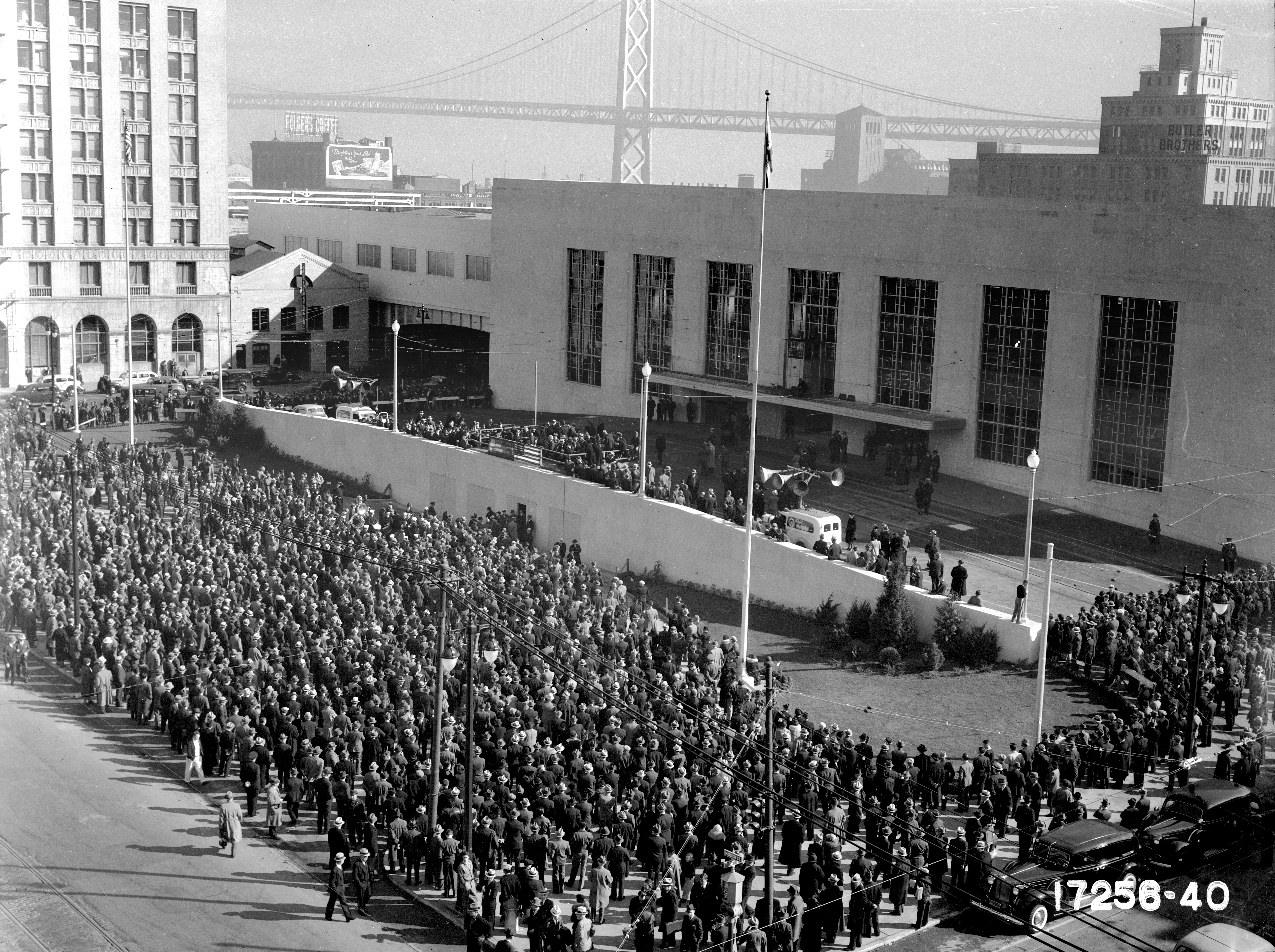
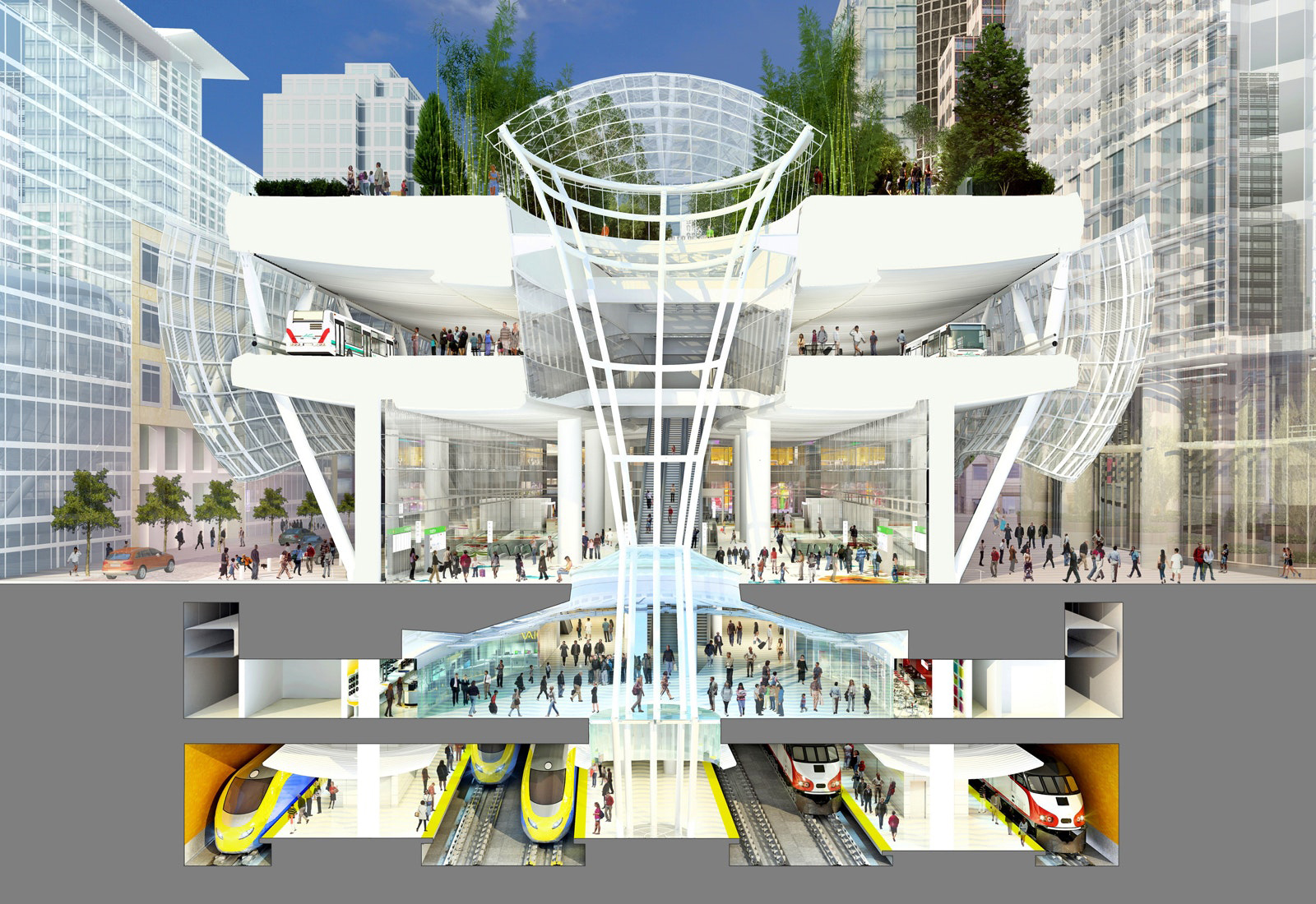
The Transbay Terminal itself was designed in the Moderne style by noted San Francisco architect Timothy Pflueger basically as a large box. Streetcars and buses disgorged passengers on the Mission Street side. They made their way up long ramps to the upper level, where six tracks handled the bridge trains from the three operators. A web of ponderous steel and concrete ramps that covered several city blocks carried the trains between the bridge and the terminal.
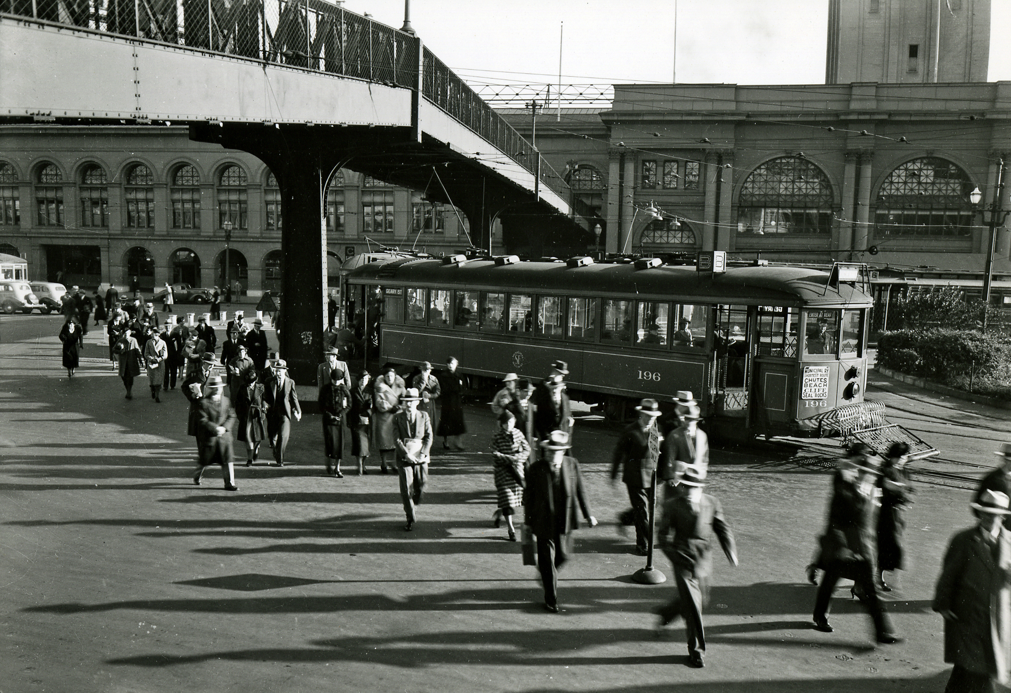
When the Transbay Terminal opened to passenger traffic in January 1939, both Muni and Market Street Railway diverted many of their Market Street streetcar lines down First Street to the terminal, returning via Fremont Street. The scene was chaotic as streetcars piled up for blocks to the west, with some cars still going straight to the Ferry holding up cars turning toward the Transbay Terminal. The mess was monumental. Soon it was clear that Ferry Building traffic was declining precipitously, as ferry service was drastically reduced, and streetcar service was adjusted accordingly.
But the full promise of the Transbay Terminal was fulfilled only briefly. The direct trains into downtown San Francisco did not stanch the hemorrhaging of interurban rail ridership, which had been under siege by the automobile for years. The ability to drive one’s car straight into town actually accelerated the interurbans’ decline. The Sacramento Northern and Interurban Electric Railroad both abandoned their bridge services in 1941, the same year that Northwestern Pacific closed down its electric passenger trains in Marin County in the wake of the Golden Gate Bridge opening in 1937 and years of declining ridership.
The Key System trains soldiered on. They looked modern, but most were actually reused parts from old streetcars encased in new bodies. The bridge speed limit for trains was 35 miles an hour, so the service wasn’t especially fast. Along with other transit agencies, though, Key System gained a reprieve as World War II rationing of gasoline and rubber forced most would-be automobile drivers back onto transit. The Key System carried 65 million riders in 1945, but ridership plummeted as the war ended, down to five million by 1957.
By that time, automobile traffic on the Bay Bridge was snarled and, with planning beginning for a rapid transit tube under the Bay and the Key System going bankrupt, the trains were kicked off the bridge, which was reconfigured as two one-way five-lane decks for rubber-tired vehicles only. The Key System gave way to a new public agency, AC Transit, which ran buses across the bridge generally following the old train routes. The curving ramps and wide platforms of the terminal were far more than buses needed to operate, but they were there, and stayed that way until 2010.
Meanwhile, the Ferry Building and surrounding blocks had deteriorated. The lack of a twice-daily commuter rush led to established small businesses disappearing, with seedier uses sometimes replacing them. In the big conversion of the late 1940s, Muni routed all seven surviving streetcar lines to the Transbay Terminal, leaving only buses to serve lower Market Street.
The automobile paid the Union Terminal and Ferry House what seemed to be the final indignity when an ugly double-deck concrete freeway was slapped up right in front of it, cutting off its façade from Market Street. The Embarcadero Freeway opened in 1959, the year after the last vestigial SP ferry service (connecting to its long-distance passenger trains) quit. Stripped of a meaningful transit role, the Ferry Building languished, its interior chopped up into offices and a private club. The whole Ferry Building area was so underused that the original design for the new rapid transit system, BART, did not include a station near the Embarcadeo, figuring there would not be enough traffic.
Rebirth
Coming to town took on an entirely new dimension in 1974 when BART’s transbay tube opened. Gleaming stations under Market Street and fast, clean trains with upholstered seats and carpeted floors promised a commuting experience quicker and more comfortable than ever before. Everything was designed for the middle-class and upscale commuter. BART leaders promised a seat for every rider and didn’t even install grab handles and stanchions to help people stand on the shiny new trains.
BART changed the Bay Area in profound ways. Alameda and Contra Costa Counties, the two East Bay BART Counties, had grown by 60 percent in population between 1950 and 1970, and then grew almost another 50 percent by 2000. By contrast, San Francisco’s residential population had dropped in the decades after 1950, finally getting back to mid-century level in 2000. Yet tens of thousands of new jobs were being created in downtown San Francisco. BART added an Embarcadero Station to meet demand from a slew of new office buildings in the area. The Montgomery Street station fostered growth of many new towers as well.
This all changed the commuter arrival experience considerably. Now, with BART, commuters had several San Francisco stations to choose from, reducing the number of transfers to local transit. Imposing facades had been replaced by underground stations with low ceilings. (Even the ornate Third and Townsend Peninsula Commute Depot had disappeared in 1975, as owner Southern Pacific cashed in the real estate on that block and built a utilitarian replacement a block west on Fourth Street, now run by public agency Caltrain.)
As for the Transbay Terminal, it continued to host AC Transit buses crossing the bridge and, later, other commuter and intercity buses. The vast waiting areas, built for crowds that never materialized, became hangouts for the homeless. Commuters did not tarry there.
Grand new vision
The Ferry Building provided a new transportation vision in 1898. The Salesforce Transit Center aspired to do the same thing 120 years later. It is the result of an effort spurred by then-San Francisco Mayor Willie Brown to convert the prime real estate covered by the old Key System train ramps into new residences and offices, while providing a 21st century transit hub and world-class park for San Francisco.
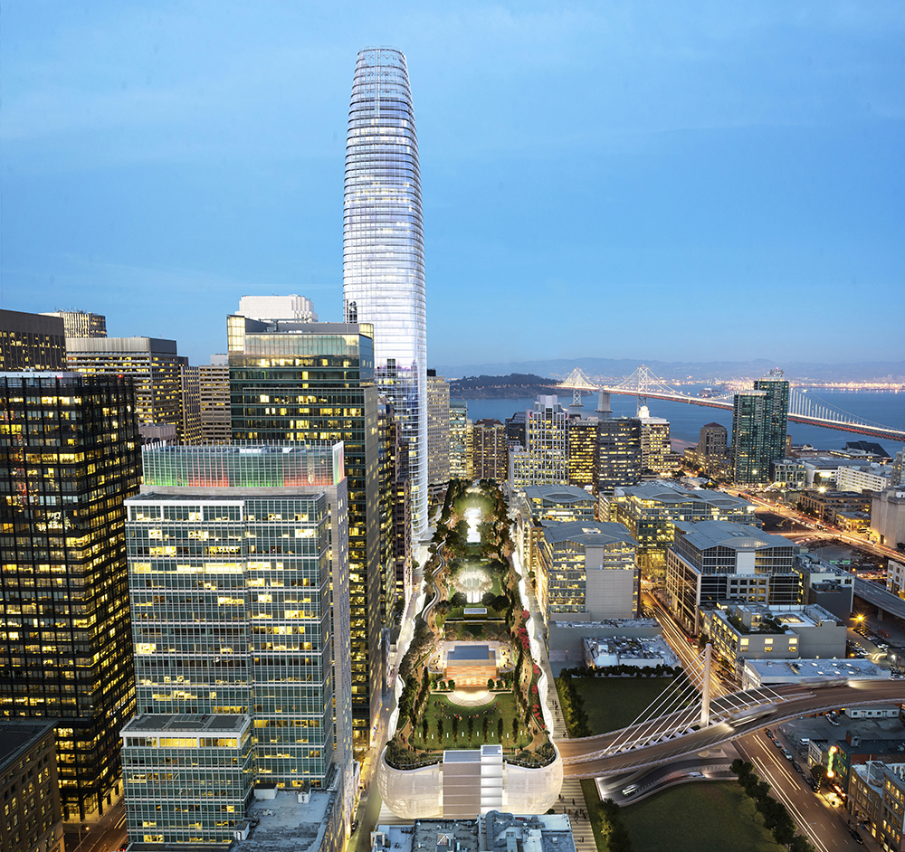
The old Transbay Terminal was ripped down in 2010, with buses going to a temporary open-air station a block away. An imposing new $2.3 billion edifice now straddles First and Fremont Streets just north of Howard Street, with bus bays above street level and a huge empty box below the street, designed to ultimately house six tracks for Peninsula commute trains and the California High-Speed Rail line to Los Angeles. All of it is topped with an incredible five-acre linear park on the roof, featuring almost 500 trees, open to the public. As for the actual site of the old Transbay Terminal, it’s now filled by San Francisco’s new king of skyscrapers, the 1070-foot tall Salesforce Tower, owned by Boston Properties. (The hometown software company Salesforce paid $110 million to put its name on the transit terminal adjoining its headquarters for 25 years.)
Block after block of the old ramp areas are now covered with high-rise residences and offices, effectively moving the center of gravity for downtown San Francisco south of Market for the first time ever.
Structural problems forced the Salesforce Transit Center to close for repairs within weeks of its 2018 opening. It only got a few months of “normal” operation after reopening before the Covid pandemic decimated bus ridership in 2020. The shift towards working from home has kept the Salesforce Tower, and other office buildings that the terminal was built to serve, operating with only a fraction of the past number of pre-pandemic workers.
The full value of this bold new vision cannot be realized without the rail service, but will the dramatic changes in work patterns persist and lessen the need for a downtown San Francisco terminal? In any event, there is currently no identified funding for extending Caltrain and future High-Speed Rail from Fourth and King Streets to the terminal, estimated to be at least $4 billion project. And while the first segment of the High-Speed Rail network is currently under construction in the Central Valley, political, legal, and funding hurdles remain to be cleared for it to reach the Salesforce Transit Center, with the earliest date anyone is currently projecting to be beyond 2030.
Ferry Building renaissance
Meantime, the Ferry Building is enjoying a vibrant third life, with its interiors restored and opened back up to the original skylights and now hosting one of the West’s finest public food markets. Ferry service was steadily reviving before the pandemic, as the bridges and BART reach capacity, with more docks recently completed, adding to those that already serve Oakland, Alameda, Vallejo, Sausalito, and Tiburon. Regular service to Treasure Island, where large-scale residential development is underway, began in 2022. While the pre-pandemic number of daily arrivals and departures, 130, is less than a third of the 1930 peak, it is an impressive comeback, with more growth planned.
And of course, back in their familiar surroundings, vintage streetcars, made possible by the efforts of Market Street Railway. Just like the Ferry Building, they’re part of San Francisco’s passion for putting the past to work, to enhance the present while building the city’s future.
By Rick Laubscher, Market Street Railway President
If you like our exclusive content, please consider even a small donation to help our nonprofit.
The author thanks Market Street Railway volunteer archivists Bob Strachan and Mike Sheridan for assembling photos used in this story, and for the exhibit, and recognizes the work of authors Michael Corbett, Harre Demoro, Michael Healy, John McKane, Nancy Olmsted, and Vernon Sappers for their fine historical accounts.

Very informative article for someone from a long way away. Thank you.
Enjoyed the read, most interesting.
This was a great presentation, Rick. It really brought together the history of the Ferry Building and transportation in San Francisco.. I will be incorporating a lot of that information in my City Guides tours. Thank you very much.
Maybe the San Francisco Bay Area had a belter. transit network then it has now. Unfortunately, governments in the 1930″shad little interest or recourses for any kind of public transit.